| Home | Newsletter | Locations | Diary |
|
Indexes |
|
|
|
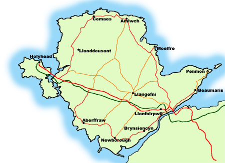
Islands Anglesey
With an area of 278 square miles it is the largest Welsh island and the 5th largest island of Great Britain. It is also the largest island in the Irish Sea as it is larger than the Isle of Man. It has many Areas of Outstanding Natural Beauty (ANOB) and a National Nature Reserve at Newborough Warren. The largest town is Holyhead and is a major port with ferry boats leaving daily with passengers and goods bound for Ireland, a ferry trip to Dublin Ireland, takes around 3.25 hours, whilst the Catamaran takes around 1.75 hours. Its county town and government centre is at Llangefni. In 2007 the population of Anglesey was around 69,000. History
Historically, Anglesey has long been
associated with
Druids,
It is rich in prehistoric remains and there are numerous megalithic monuments and structures present on the island. A number of Iron Age and Roman sites have been excavated, and coins and ornaments discovered to confirm that Anglesey was inhabited during this time, evidence of humans on the island as far back as 7000 BC.
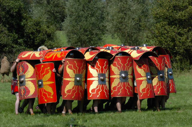
In AD 60 the Roman General Gaius Suetonius
Paulinus, invaded the island and made use of the minerals, climate
conditions and agricultural land to their advantage. However he left with
his army soon after, when news of Boudica's revolt reached him. It was
finally brought into the Roman Empire by Gnaeus Julius Agricola, the Roman
Governor of Britain, in AD 78. See
Romans on Anglesey
When the Romans left Britain in the early 5th century, pirates from Ireland colonised Anglesey and the nearby Llŷn Peninsula. In response to this, Cunedda ap Edern, a Gododdin warlord from Scotland, came to the area and began the process of driving the Irish out. This process was continued by his son Einion Yrth ap Cunedda and grandson Cadwallon Lawhir ap Einion, the last Irish invaders finally being defeated in battle in 470. After the Irish, the island was invaded by Vikings, and it is thought the name Anglesey is to have come from a Viking place name. Then the Saxons and Normans invaded before it fell to Edward I of England in the 13th century. As an island, Anglesey was in a good defensive position and, because of this, Aberffraw became the site of the court (Llys) of the Kingdom of Gwynedd. Apart from a devastating Danish raid in 853 it was to remain the capital until the 13th century, when improvements to the English Navy made the location indefensible.
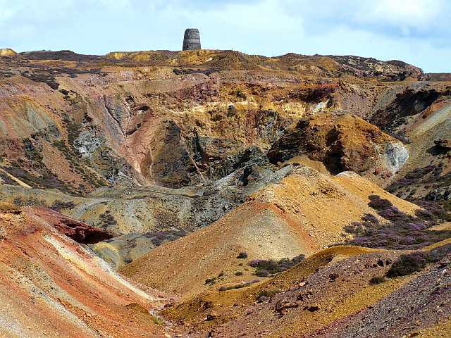
As with many parts of Wales, Anglesey has a
mining heritage. First off it was lead ore and silver and then Copper, by
the 18th century Amlwch at the north of the Island was the Copper Capital of
the world. At its peak it was producing 3,000 tonnes per year and over a 150
year period more than 3.5 million tones of ore was raised. At this time
Amlwch was also the second largest town in Wales, second only to Merthyr
Tydfil (coal mining), with a population of around 10,000. There were around
1500 men and women working in the mines, the rest of the population being
other trades, business, and families that built up around this. By the mid
19th century copper started to decline and the main industry became ship
building. The
Amlwch Copper Kingdom
Parys Mountain
Agriculture has always been a big part of
Anglesey life, with many people using the land and sea to make a living.
Populations around the island grew at various times when exploitation of
other resources were being harnessed, like Copper in the 18th and 19th
centuries which saw an influx of people to work in the mines. Then again at
the beginning of the 19th century when Thomas Telford built the
Menai Suspension Bridge
Today employment on the island is primarily agriculture and tourism with about 2 million people visiting each year making use of the vast amount of recreational activities both on sea and land. Towns and Villages The historic town of Beaumaris is the site
of one of the castles built by Edward I after his defeat of the Welsh
Princes,
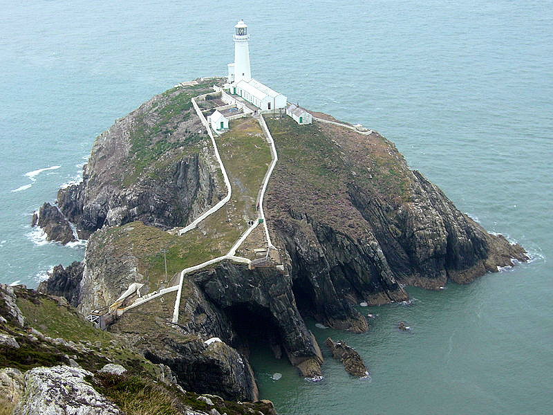
Beaumaris Castle. Holyhead is on Holy Island off the west
coast and
is a major ferry port taking passengers and cargo across to Dublin in
Ireland. It has the largest population of around 11,000 in 2005. Here there
are a wealth of attractions to see including the
Caer Gybi Roman Fort,
South Stack
Lighthouse
Llangefni is the county town of Anglesey
and where the government administration is carried out. It is also home to a
large nature reserve, the
Dingle Nature Reserve
Menai Bridge which is one of the entry
points onto the island, when you take the A5 from mainland Wales and travel
over Thomas Telford's
Menai Suspension Bridge.
Amlwch and the nearby Parys Mountain was the
Copper Capital and during the 18th and 19th centuries it was the largest
copper mine in the world, and at this time was the second largest town in
Wales with a population of around 10,000. By the mid 19th century when
copper mining started to decline it then became a ship building port, you
can find out more in
Amlwch Copper Kingdom,
Moelfre is on the East coast and has a heritage
of daring sea rescues and major shipwrecks seen off Anglesey. The
Seawatch Centre
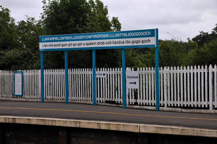
The Village with the Longest Name Anglesey's other claim to fame is that, according to the Guinness Book of Records, it has the village with the longest name in the world, Llanfairpwllgwyngyllgogerychwyrndrobwyllllantysiliogogogoch and translated into English you get:-
The long name was actually created in the
19th century, by local businessmen who wanted to attract tourists to the
Island. The story goes that a businessman had a secret cure to 'Lock Jaw'
and when visiting his shop and asking for this cure he would hand you an
envelope, which inside had a piece of paper with the full name of the
village printed on it! It is abbreviated to Llanfairpwll or Llanfair P.G. by
the locals today, and on Ordnance Survey Maps is shown as Llanfair
Pwllgwyngyll. It is the first village you enter coming over the
Britannia Bridge
Harnessing Nature Being an island it can sometimes be a very
windy place and the abundance of this resource has in the past provided a
useful source of energy. There are records of windmills being built from the
14th century. However those on the island today, were build during the 18th
and 19th centuries when numerous windmills were built all over the island.
Almost 50 are known to have been built. The last mill to stop working was in
1936. In 1978 on of the mills at Llanddeusant,
Llynnon Mill,
There were also Water Mills, using the
power of water from streams and lakes like the one at Llanddeusant,
Howell Watermill. Today there are 3 large wind farms who are still using the power of nature to produce energy for us. Lighthouses Being an island Anglesey is surrounded by the sea and was a strategic coastal point for ships coming into and out of the Liverpool Dock. To help guide ships around it, and it's many islands, a number of lighthouses were built as well as the use of sea markers. The lighthouses on Anglesey include:
Amlwch
Lighthouse, Anglesey
Llanddwyn Island Lighthouses,
Anglesey
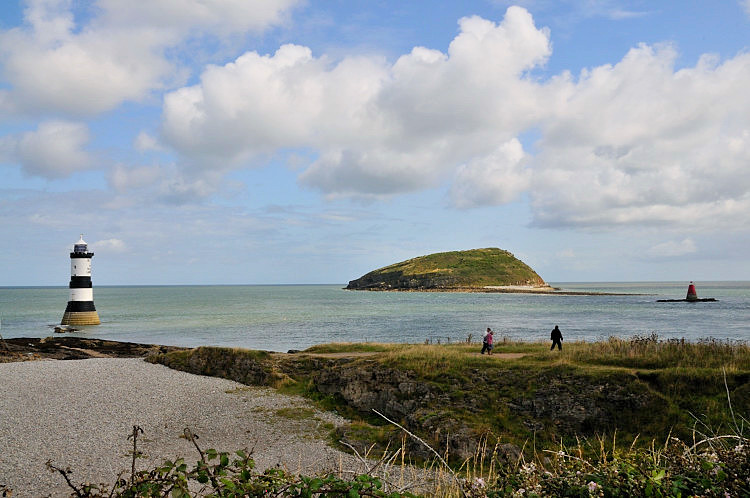
Penmon Lighthouse,
Anglesey
Point Lynas
Lighthouse, Llaneilian, Anglesey
Salt Island
Lighthouse,
Holyhead, Anglesey
Skerries Lighthouse (The), Anglesey
South Stack
Lighthouse, Anglesey
We have only so far written up one of the
Sea Marks, that of the
White Ladies Sea Marks
What to See Coastal and other views, wildlife, geology and
holidays focusing on natural heritage are a major element. There are no
motorways, the two major routes are the A55 and A5 which travel from
mainland Wales near to Bangor and Conwy on to Holyhead. There is a group of
A routes that nearly form a circular route and a few B roads, but there are
also many smaller roads or lanes, so getting from one place to another is not fast. There are
bus routes and a many footpaths including the
Anglesey Coastal Path
We have put
together a list of
Anglesey Attractions
The location guides we have created so far include:
Amlwch Copper Kingdom, Amlwch, Anglesey
Amlwch
Lighthouse, Anglesey
Barclodiad y Gawres Burial Chamber, nr Aberfrraw, Anglesey
Beaumaris Castle, Anglesey
Beaumaris Courthouse, Beaumaris, Anglesey
Beaumaris Gaol,
Beaumaris, Anglesey
Bodowyr Burial Chamber, nr Brynscienyn, Anglesey
Britannia Bridge, nr Llanfairpwll, Anglesey
Bryn Celli Ddu Burial Chamber,
nr Llanfairpwll, Anglesey
Bryn Gwyn Standing Stones, nr Brynscienyn, Anglesey
Caer Gybi Roman Fort, Holyhead, Anglesey
Caer Leb, nr Brynscienyn, Anglesey
Caer y Twr Hillfort, nr Holyhead, Anglesey
Capel Lligwy nr Moelfre, Anglesey
Castell Bryn Gwyn, nr Brynscienyn, Anglesey
Cemlyn Nature Reserve and Bay,
nr Tregele, Anglesey
Church Island,
nr Menai Bridge, Anglesey
Din Dryfol Burial Chamber, nr Aberfrraw, Anglesey
Din Lligwy Hut Group, nr Moelfre, Anglesey
Dingle Nature Reserve (The),
Llangefni, Anglesey
Holyhead Mountain Hut Group, Holyhead, Anglesey
Howell Watermill, Llanddeusant, Anglesey
Llanddwyn Island Lighthouses,
Anglesey
Llanfairpwll Station, Llanfairpwll, Anglesey
Llangefni Windmill, Llangefni, Anglesey
Llangwyfan Church,
Llanwyfan, Anglesey
Lligwy Burial Chamber, nr Moelfre, Anglesey
Llynnon Mill,
Llanddeusant, Anglesey
Marquess of
Anglesey Column, Llanfairpwll, Anglesey
Menai Heritage Experience, Menai Bridge, Anglesey
Menai Suspension Bridge, Menai Bridge, Anglesey
Penmon Cross, Penmon, Anglesey
Penmon Dovecot, Penmon, Anglesey
Penmon Lighthouse,
Anglesey
Penmon Priory, Penmon, Anglesey
Penrhos Feilw Standing Stones,
nr Holyhead, Anglesey
Plas Newydd,
Llanfairpwll, Anglesey
Point Lynas
Lighthouse, Llaneilian, Anglesey
Puffin Island,
Penmon, Anglesey
Prysaddfed Burial Chamber, Prysaddfed, Anglesey
Salt Island
Lighthouse,
Holyhead, Anglesey
Seawatch Centre,
Moelfre, Anglesey
Skerries Lighthouse (The), Anglesey
South Stack
Lighthouse, Anglesey
South Stack,
nr Holyhead, Anglesey
St Seiriols Well, Penmon, Anglesey
Tacla Taid Transport and Agricultural Museum,
Newborough, Anglesey
Trefignath Burial Chamber,
nr Holyhead, Anglesey
Ty Mawr Standing Stone,
nr Holyhead, Anglesey
Ty Newydd Burial Chamber,
nr Llanfaelog, Anglesey
White Ladies Sea Marks,
Carmel Head, Anglesey
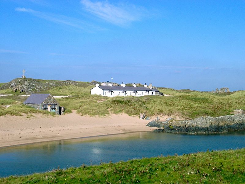
Other Nearby Islands Anglesey is surrounded by many other islands, some large and some small and it has a number of beautiful peninsulas as well. Here we have listed some of them.
Church Island
Cribinau
East Mouse
Holy Island
Middle
Mouse
Puffin Island
Salt Island
The Skerries
South
Stack
West Mouse
Ynys
Castell,
Ynys Dulas
Ynys
Feurig
Ynys Gored Goch
Ynys
Llanddwyn
Ynys
Moelfre
Links and Lists .
|
|||||||
|
|||||||
| . | |||||||
|
|||||||
|
|