| Home | Newsletter | Locations | Diary |
| Indexes |
|
| Travellers Resource |
|
|
|
|
|
|||||||||||||||||||||||||||||||||||||||||||||||||||||||||||||||||||||||||||||||||||||||||||||||||
|
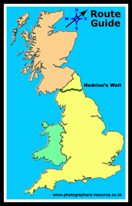
Hadrian's Wall is a "A World Heritage Site", situated in the North of England covering three of our counties of Cumberland, Northumberland and Durham from the West coast to the East coast. Most guides to the wall start it at Bowness on Solway, although the map/guide called Hadrian's Country takes it back along the west coast down to Ravenglass at the south of the Lake District. For this guide we are going to concentrate on
covering the wall by car, and will take you to those places that are easily
accessible via this method and as there is very little physical structural
remains prior to Banks East Turret just outside Banks, we will start this guide
from here. Prior to this point much of the western wall (about 30 miles) was
built of turf with stone turrets and overtime turf gives way and therefore
little exists today. For a detailed history on the wall then see
Hadrians Wall.
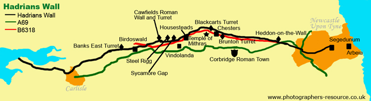
To cover Hadrian's Wall even by car it will take a number of days, to stop off at each of the significant points and then to take time at each of the major attractions. Some of the attractions on this route are not actually on the wall, but are near to it and they played a significant part during Hadrian's time here. So prior to your journey using this guide you should be able to get a good idea of what can be seen, how long at least to allow at each place and therefore be able to work out how long you need to complete your trip. We did the wall in two parts (each two days long) one starting from the West and the other from the East. Two Ordnance Survey Explorer Maps OL43 and 316 cover the wall and it is worth investing in these are many of the turrets and smaller points are on un-numbered or unclassified roads. A number of turrets are identified on the with the word 'turret' but they are not labelled, so using the map in combination with this guide will allow you to identify what to see. Many of the turrets and other smaller sites have information boards with illustrations of how it may have looked. We are starting our journey at Banks East Turret. To get here from the M6 J43 take the A69 which joins Carlisle and Newcastle Upon Tyne. Just past Brampton there is a road on the left to Lanercost, at the priory follow the road to the right and follow the signs to Banks. At Banks take the right fork at the Y junction which is signposted to Gilsland.
Here there is a well preserved turret as well
as some good lengths of adjoining stretches of wall. The road is narrow, but
there is a parking area for you to stop and take in what you can see, and the
stunning views across the countryside. If it's wet like on our visit then the
views may not be as stunning. Also within the same vicinity and can be reached
from the same car park is
Pike Hill
Signal Tower, Jump back in your car and continue along the road towards Gilsland, and a little further along at Leahill, there are the remains of two further turrets, Leahill and Piper Sike. Piper Sike has a cooking-hearth within it.
As you travel along this road and you get to Appletree, to the right away from the road, and not easy to see from the car, is the remains of a section of turf wall. It runs along the edge of the Vallum, south of the main wall, and runs from here towards Birdoswald Roman Fort.
Birdoswald is the first major site on the wall when following it from west to east. It is a Roman Fort, set on a high spur overlooking the River Irthing, and it has the best preserved defences of any of the major forts on this route. Today we see the remains of the defensive wall and gateways, with the south gateway and its oven, the headquarters building, barracks and granaries as well as wooden posts which show where two timber halls replaced the granary building. There is a large pay and display car park just past the main entrance the road takes a sharp left turn and goes downhill slightly, so you have to walk back up again to gain access through the visitor centre.
From Birdoswald there is a section of wall
which goes out across the fields and the next focal point is
Milecastle 49 Harrow's Scar
On leaving the Birdoswald car park take a right and at the next road junction turn right onto the B6318 and head towards Gilsland. Go through Gilsland and just over the railway take the night right towards Gapsheild. Find somewhere to park up safely and take a walk across the fields to Milecastle 48 - Poltross Burn. It is situated right next to the railway line and is one of the best preserved milecastles on the wall. Remains include it's north gateway, a stair to the rampart walk and an oven.
From this milecastle return back to the B6318
and go towards Greenhead, continue on the B6318 through Greenhead and take
the next left to the
Roman Army
Museum.
From here rejoin the B6318 and continue east. The next point of interest is at Cawfields. At the crossroads for Haltwhistle take the left towards Cawfields Quarry. There is a car park (max 40 bays), toilets including disabled, and a picnic site at the base of the quarry and you can get some spectacular reflections in the water. From here you leave the car and walk alongside the quarry water and up onto the cliff top. It is a meander and not a steep climb, although the final piece to the top of the crag is a lot steeper. At the top you get to Cawfields Roman Wall and Milecastle 42. There are some good remains of a milecastle here, and you can see a good stretch of the wall as it follows the hillside into the distance. From the top of the crag you can get some good aerial views of the wall going East and it is probably one of the best photo points on the wall.
Return back to the B6318 continue East
and take the next left. This road takes you in a loop around to Steel Rigg
another good viewpoint for the wall. Many would continue down the B road to
Once Brewed and then turn left as the tourist signs point you this way to
Steel Rigg. However doing this you miss a section of the wall which is just
visible from the B road, but is better viewed and easier to photograph from
this loop road. The advantage of using this road is that little traffic
does, so you are able to stop at various points and get some good photos of
Winshields Wall,
When you reach Steel Rigg there is a pay and display car park, and this is another good point to get out and stretch your legs and take in the spectacular views. This is in my opinion the best viewpoint on the Wall, not just for seeing the wall, but the surrounding scenery is spectacular. As well as the wall you can also see Crag Lough into the distance. Here it is possible to get panoramic views.
Back at the B6318 go straight over down the road next to the Once Brewed Visitor Centre. This is the main visitory centre for the National park and World Heritage site. It is also the point where the Pennine Way crosses. Within the centre there are exhibitions, tourist information and parking. Continue past the visitor centre and take the next left signposted to Vindolanda Roman Fort. Follow this single track road until you come to the car park and picnic site on the right. Vindolanda is a large Roman Fort and settlement which predates Hadrian's Wall. Excavations have uncovered numerous buildings and some well preserved artefacts, but it also has a full size replica section of Hadrian's Wall built of wood and stone.
Get back onto the B6318 continue east towards
Housesteads Roman Fort and keep your eye open on the left so that you don't
miss probably one of the most recent iconic images of the 20th century,
Sycamore
Gap and Castle Nick,
From here the next major stop off point is Housesteads Roman Fort. This is the best preserved roman fort in Britain, and is one of 12 forts added to the Wall in around AD124. It was designed to contain a garrison of 800 soldiers. Excavations show the granaries, barrack blocks, headquarters building, commanding officers residence, a hospital, bathhouse, latrine, all four gateways and the remains of turret 36b which was here before the fort. The large car park is directly off the B road at which there are toilets, a picnic area and a National Trust shop. You walk under the archway and follow the path up the hill to the Museum and ticket office. Once you have your ticket then you walk across hill a little further up hill to enter just before the south gate.
The views from up here are great and although
it is difficult on the ground to take in the enormity of these remains, you
can see from the aerial images in our location guide
that it is large and there is a lot to see. Whilst up here, before walking
back down hill to your car it is worth taking a slight detour west to follow
the wall back to
Milecastle 37.
Continuing on along the B6318 at Shelid on the
Wall the next stretch of road now follow the course of Hadrian's Wall and it
switches from one side of the road to the other, identifiable by turf
mounds. Your next port of call is the car park at
Brocolitia
Roman Fort
Back on the road and continuing east on the
left you will see
Blackcarts Turret. The next port of call is Chesters Roman Fort. The best preserved cavalry fort in Britain. It has a well preserved commandants house and the bath house, nearest the river, is the best I've seen to date with its complex of rooms offering customers hot, cold and steam baths. From the bath house take a look across the river and across the on the eastern side and you will see the remains of Chesters Bridge Abutment which carried Hadrian's Wall across the River Tyne. The museum displays a wide collection of Roman finds mainly those retrieved by John Clayton and include important early discoveries of the central section of the wall.
Back on the B6318 head to Chollerford and at
the roundabout continue to follow the B road over the stone river bridge. At
the next crossroads go right onto the A6079, along on the lefthand side is a
small parking area. Off of here and across the field you get to
Brunton Turret and
Wall,
After taking a look at this get yourself back onto the B6318 and continue east once again the road travels the course of Hadrians Wall, with it crossing the road and running down either side. The National Trail Path keeps to the right side. At the roundabout where the B road joins the A68 take a right and head to Corbridge, and visit the Corbridge Roman Town. This is a series of forts at an intersection of two major roman roads, Stanegate and Deer Street. It's earliest parts, a fort, dates from around AD139. It became a busy garrison town and the remains you see include the remains of a fountain house with aqueduct, a pair of granaries and walled compounds for the military, containing barracks, temples, houses and a headquarters building with an underground strong room, as well as a piece of the Stanegate Road. There is also an onsite museum which displays a selection of Roman finds.
Retrace your route back up the A68 to the
roundabout to continue your journey onto Newcastle Upon Tyne following the
B6318.There is not much to see along this stretch but it is a pretty and
enjoyable journey in the countryside before you hit the metropolis. At
Heddon-On-the-Wall you now join the B6528. The next stop is
Heddon-on-the-Wall
Continue to follow the B6528 through Throckley
until it joins the A69. Before entering Newcastle there are some
sections of the wall to be found amongst the houses and streets like that of
Denton Hall Turret.
From here rejoin Denton Road and go straight
across on the B6328 into Whickham View. Take a left into Rushie Avenue and
right into Bertram Crescent take the 3rd left into Broomridge Avenue where
you will find the Vallum Crossing and in the same area, Dunhill Park are the
remains of
Benwell Roman Temple.
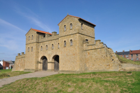
From here you could continue through Newcastle on the A186 which takes you all the way to Wallsend, Segedunum Roman Fort. However it is quicker to bypass the City Centre by getting back onto on to the A167, coming off on the A1058, Coast Road. At the junction of the A186 take a right into Station Road, go over the A193 junction and then turn right into Buddle Street, Segedunum is on your right. Segedunum Roman Fort stood on the banks of the River Tyne, and was the last outpost of Hadrian's Wall. For almost 300 years it was home to 600 Roman soldiers. It is the most excavated Fort along the Wall, although with the least amount to see except outlines to show where buildings once were. It has a large interactive museum and a 35 metre high viewing tower which gives a good aerial view of the site. They have also reconstructed a Roman Bathhouse, showing you what they think it looked like in its day. Across the road there is also a reconstructed piece of a Roman Wall as they think it looked like, which you can climb onto.
It is at Segedunum just the other side of the perimeter fence that is the east end of the Hadrian's Wall Path (National Trail). This you may think is the end of our journey, but there is one more Roman site that is worth a visit now that you have come this far. It is four miles east of the end of Hadrian's Wall at South Shields. To get there take the A19 through the Tunnel to Jarrow. Where the tunnel exists at the next roundabout take the A185 and then A194 to South Shields. At the roundabout with the B1344, Station Road, at the third roundabout go right at next roundabout go left into Mile End road, then right into Green's Place and then the next major right into Baring Street, your destination Arbeia Roman Fort will be on your left. Arbeia was built to guard the entrance to the River Tyne. It was built around AD160 and the stone fort played an essential role in the mighty frontier system. Originally built to house a garrison, Arbeia soon became the military supply base for the 17 forts along the Wall. It was occupied until the Romans left in the 5th century. Today, we can see excavated remains and reconstructions of original buildings on their original foundations include a roman Gatehouse, a barrack block built using traditional techniques of the 3rd century and the Commanding Officers House which has been fitted out with authentic furniture and wall paintings. There is also a museum building that houses artefacts and finds discovered at the Fort, and all of this combines to give an insight into life in Roman Britain.
So this has brought our tour to an end. Of course we have run it from West to East, but you could do it from East to West. Either way you get to see some fantastic sites, and get to learn about the Roman history of Britain. |
|||||||||||||||||||||||||||||||||||||||||||||||||||||||||||||||||||||||||||||||||||||||||||||||||
| Further Information Direct Drive times by car between the major venues on this route
See our other pages relating to Hadrian's Wall.
Hadrian's Wall - Featured Places
Please let us know any other information that we can add to the Grid(s) or page and any errors that you discover. Before making a long trip to any location it is always wise to double check the current information, websites like magazines may be correct at the time the information is written, but things change and it is of course impossible to double check all entries on a regular basis. If you have any good photographs that you feel would improve the illustration of this page then please let us have copies. In referring to this page it is helpful if you quote both the Page Ref and Topic or Section references from the Grid below. To print the planning grid select it then right click and print the selected area. Please submit information on locations you discover so that this system continues to grow. |
|
||||||||||||||||||||||||||||||||||||||||||||||||||||||||||||||||||||||||||||||||||||||||||||||||
. |
|||||||||||||||||||||||||||||||||||||||||||||||||||||||||||||||||||||||||||||||||||||||||||||||||
|
|||||||||||||||||||||||||||||||||||||||||||||||||||||||||||||||||||||||||||||||||||||||||||||||||
|
|
|||||||||||||||||||||||||||||||||||||||||||||||||||||||||||||||||||||||||||||||||||||||||||||||||