Article
Time Planning for
Coastal Photography
|
Most landscape and similar
photography benefits from similar considerations, like where the lights coming
from, time of day, season, and perspective. Coastal photography is no exception,
but you have less options available to you unless you have a helicopter or other
means to move off the cliff and over the sea.
Most of the coast does not run in straight
lines but meanders along, on most stretches of coastline you will find parts that face many different compass positions. This means that any part
of the day when the sun is showing there will be photographic opportunities
to get the effect that you want, however some
locations will be more difficult that others.
There are other variables, such as the
season, height of plants that are blocking your view, the state of the tide,
weather, and accessibility.
The question is often can we line up the
collection of variables that would work well for us. We can often narrow
down the season, and some other considerations, we can use tide tables to
see how the tide lines up on different dates with our preferred lighting
direction and from this get perhaps a list of dates and times that would
work for us. It's then a case of hoping that our diary, and other commitments,
line up with these and that the weather is ideal.
If we have a specific goal, to take a
specific view then we can follow the plan above, but often we don't we are
just going out with our camera, and expect as we move along a coastal past
or stop at different points where we can get a view for the conditions to be
sometimes with us and sometimes against us. Over much of the coast you can
take shots in at least two directions, as we walk along a coastal path,
forward or backwards, at some points we may have other opportunities as well
such as photographing an estuary, or an island. We may also have decided on
a date, or just want to make the best of a weather condition or have some
other criteria. However even in these cases we can apply some planning, in
that we can select where we start and end and the direction that we travel.
It may seem not to make a lot of difference if you sat at one end or the
other of a walk, however it would mean that the tide would be at different
states along it. Often we would like to see the tide in estuaries, at resorts
and the like, while with interesting cliffs with rocks below and with rock
pools we may prefer it to be out.
Sunsets and sunrises over the ocean can also be a subject worth considering.
To plan these |
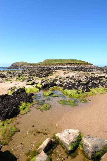
 Rock Pools to Islands are all found at the coast

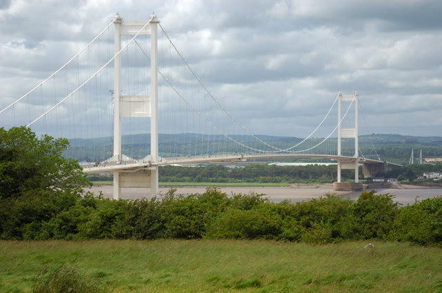
 The Severn Bridge from Aust
 |
you will need to consider where the sun is going to rise or set and the
time. These will vary throughout the year from an earlier more southern
angle in the winter to a northern angle and later setting in the summer. The
variation from rising in the east and setting in the west is northerly by up
to 30 degrees in the summer to southerly by around 30 degrees in the winter.
You also get some variation in practice according to the landscape.
Information available
To be able to plan, we ideally need some
information, We can look at maps, and aerial photographs, with
Multimap
 and
Google maps,
often on the aerial photos we can see the coastal paths and work out what we
would be able to see from each point, as well as the direction we would be
facing. and
Google maps,
often on the aerial photos we can see the coastal paths and work out what we
would be able to see from each point, as well as the direction we would be
facing.
From our reference section
 you can see other mapping systems well.
The weather is a different matter, as it can
often rain on one side of a hill and be fine on another. So most forecast as
a general trend only. We have a page within the reference section on weather
forecasts, but those of particular interest relating to coastal photography
are:-
-
BBC Coastal forecasts
updated twice a day at 5am and 5pm (1 hour later
in summertime).
-
BBC coastal observations
shows you the latest on the ground report,
updated every 3 hours.
-
The
met office website
provides more general forecasts for up to 15 days,
but I would question, given the variability of our weather here, if this is
likely to be a great deal of use. I suspect that in some cases it will be
correct but in many others just guessing what's gong to happen tomorrow
can be a challenge.
As you may guess we have a page in the
reference section with links to sites that can tell you the
sunrise, sunset
as well as similar information for the moon. Many of us carry a sun compass
in our camera bags this is used to get a good idea of where the sun will
rise and set and the height at different times of the day. If you don't have
one a good substitute is a printed sheet that you can line up with a map or
compass. Print
your own sun position compass is a PDF file we have that can be
printed to meet this need. This can be cut out and folded, and contains
instructions. This version was calculated for Derbyshire (UK) as
Derbyshire's around the middle of the UK in a north south direction, you can
use this throughout the UK and it will be very near. It also shows the suns
elevation at different points in the year, to correct this for a location,
every 100 miles south increase the angles by 1 degree and every 100 miles
north reduce them by 1 degree. Use this as a guide, particularly in hilly or
mountainous areas where the sunrise and sunset positions can be affected by
the relative height of the landscape. sunset
as well as similar information for the moon. Many of us carry a sun compass
in our camera bags this is used to get a good idea of where the sun will
rise and set and the height at different times of the day. If you don't have
one a good substitute is a printed sheet that you can line up with a map or
compass. Print
your own sun position compass is a PDF file we have that can be
printed to meet this need. This can be cut out and folded, and contains
instructions. This version was calculated for Derbyshire (UK) as
Derbyshire's around the middle of the UK in a north south direction, you can
use this throughout the UK and it will be very near. It also shows the suns
elevation at different points in the year, to correct this for a location,
every 100 miles south increase the angles by 1 degree and every 100 miles
north reduce them by 1 degree. Use this as a guide, particularly in hilly or
mountainous areas where the sunrise and sunset positions can be affected by
the relative height of the landscape.
Visiting costal areas in other countries
The considerations we have discussed above
apply equally well to most other countries. |