| Home | Newsletter | Locations | Diary |
|
Indexes |
|
|
|
|
|
|||||||||||||||||||||||||||||||||||||||||||||||||||||||||||||||||||||||||||||||||||||||||||||||||||||||||||||||||||||||||||||||||||||||||||||||||||||||||||||||||||||||||||||||||||||||||||||||||||||||||||||||||||||||||||||||||||||||||||||||||||||||||||||||||||||||||||||||||||
|
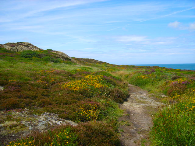
The 125 mile Anglesey Coastal Path is a circular route around the Welsh island and was officially opened in June 2006 by the First Minister of Wales at that time, Rhodri Morgan, who unveiled a plaque to mark the start and finish of the walk at St Cybis Church in Holyhead. It includes the whole coastline of Anglesey including Holy Island and there are very many places you can stop off and visit along the way. It falls within a designated Area of Outstanding Natural Beauty, which covers 95% of the coast and goes directly through 20 towns and villages. It passes through landscape that includes a mixture of farmland, coastal heath, dunes, salt-marsh, foreshore, cliffs and a few small pockets of woodland and includes a National Nature Reserve. It also passes a vast amount of ancient and industrial remains including burial mounds, hut circles, holy wells, churches, brickworks and other industrial buildings. All of this links up with village services and convenient bus stops. Of the total distance, 60 miles is public rights
of way, 28 miles of public highway, 9 miles of permissive path and 28 miles of
other access including National Trust and Forestry Commission land. Some of the
route also follows the shoreline and goes along beaches, sand dunes, river
estuaries and other such areas that have tidal restrictions, details of which
can be found
here.
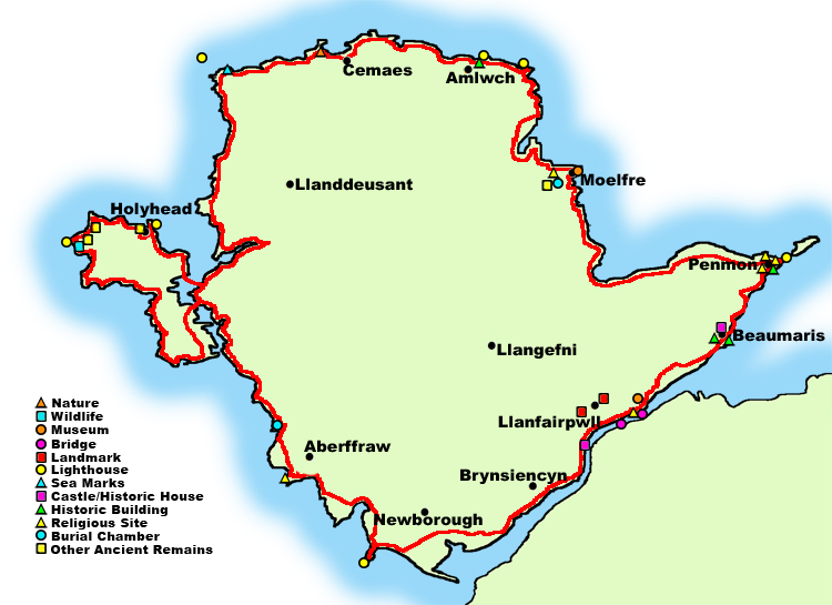
The map below shows the whole path and some of the places we have locations guides for on Photographers Resource have been highlighted, and as a quick way for you to get to these we have hot-linked them. So putting your mouse over any of the symbols on the map will bring up a description, and pressing the mouse button will reveal the page with more information on that location.
On the
Coastal Path official website
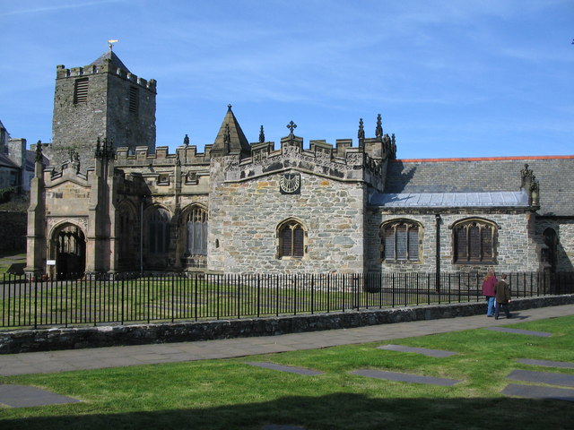
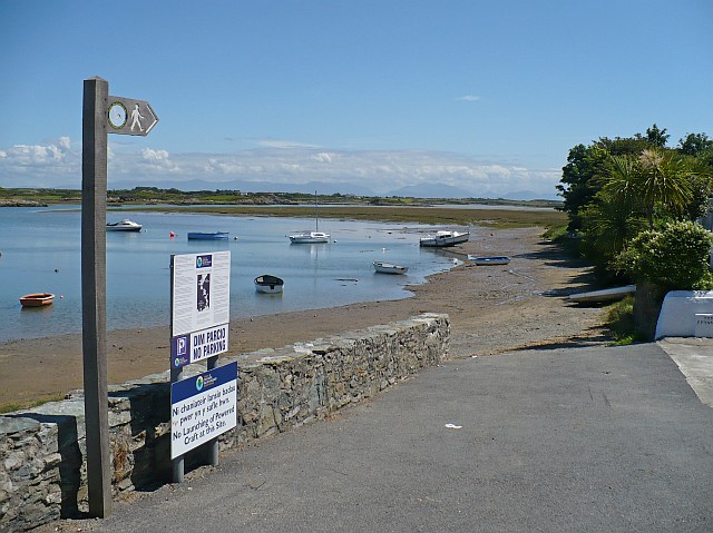
This guide starts at Holyhead, the official start point, and travels clockwise around the island, linking to other location guides we have on places of interest along it. Holyhead to Porth Trywn Bay (12 miles) The official start point of the walk is St
Gybi's Church in Holyhead. Before leaving this church take time to take a
look at
Caer Gybi Roman Fort
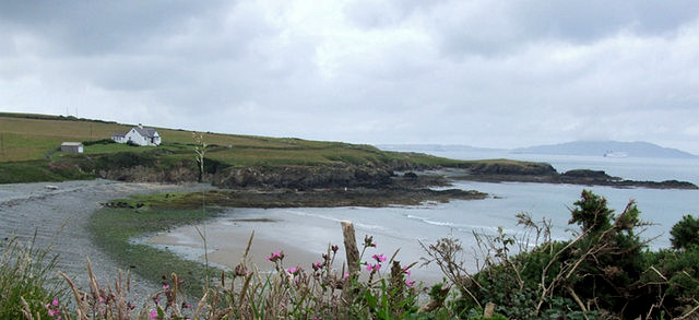
Porth Trwyn Bay to Cemaes (12 miles) This section of the path takes you through
some stunning scenery much of which is owned and cared for by the National
Trust. As you reach Porth Swtan (Church Bay), take time out to visit Swtan
Folk Museum which is housed in the last remaining thatched cottage on
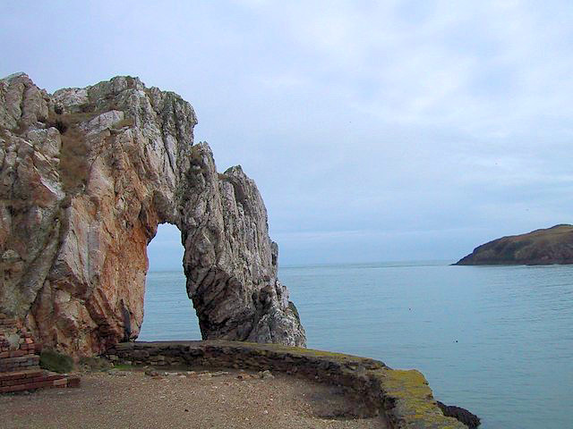
Anglesey. Continuing on you get rocky coves and steep cliffs passing a sea arch and island at
Ynys y Fydlyn all the way to Carmel Head, where the path passes in front of
the lower of the beacons, Carmel Sea
Markers, known locally as
Two White Ladies. From here you continue along the coast
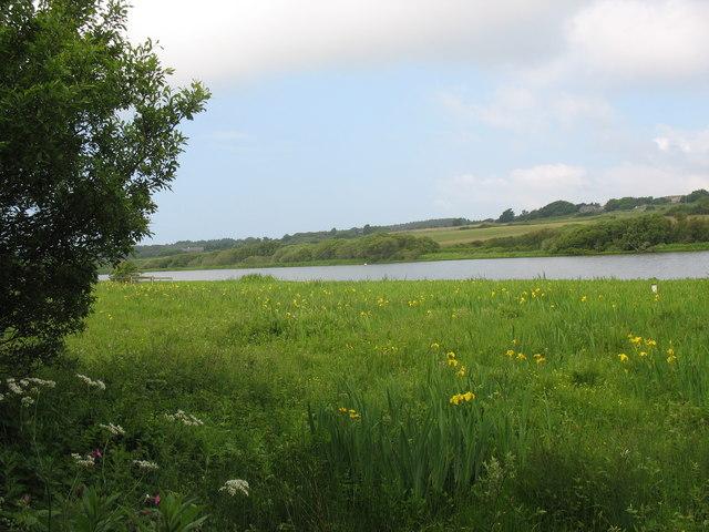
until you reach the Cemlyn Lagoon part of the
Cemlyn Nature Reserve and Bay.
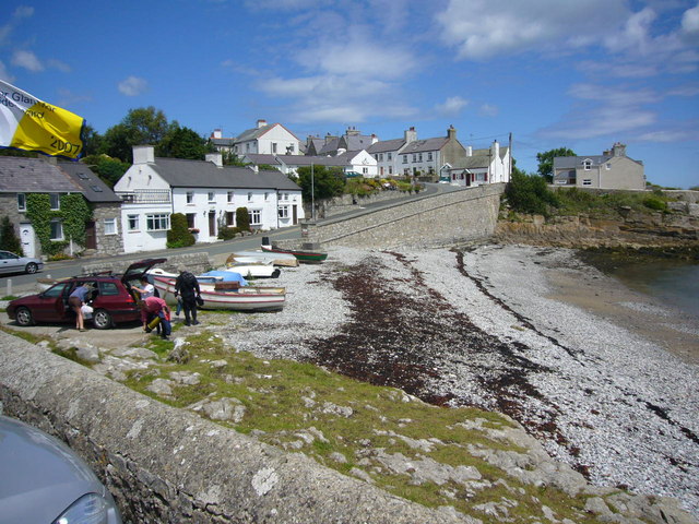
Cemaes to Amlwch Port (7.5 miles) From Cemaes the path is now on rocky cliff tops to Porthwen, before then following low rocky cliffs into Amlwch Port. At the start of this part you pass Cemaes Bay, which was the centre of the coastal trade and of the smuggling that went with it, before Amlwch harbours was built in the 18th century. It has 5 beaches, 3 of sand and 2 of pebbles. Then you go up some steep steps to join the National Trust cliff path, Penrhyn Mawr. From here you walk around headlands and across fields and down lanes passing points of interest such as Llanbadrig Church, beaches including Bull Bay where you may see seals, porpoises and dolphins playing in the warm waters, and a watch tower.
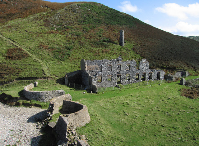
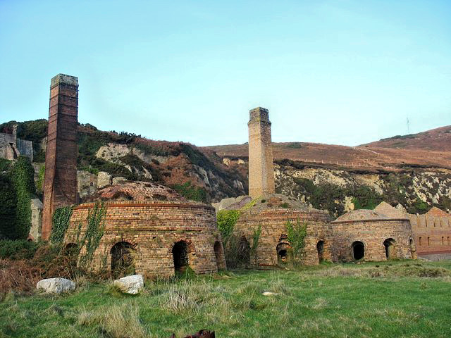
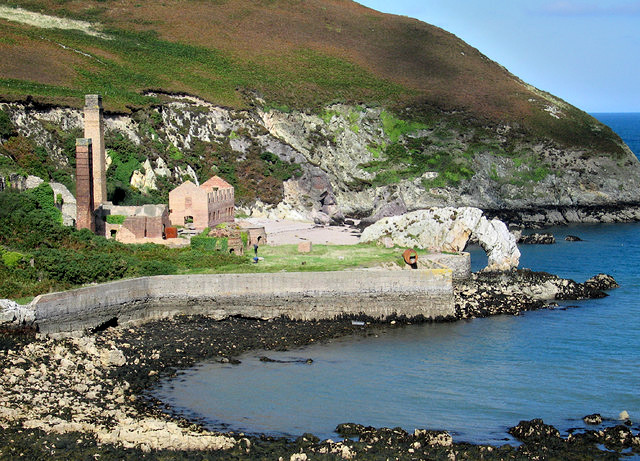
Remains of Llanlleiana Porcelain Works At Porth Wen you could visit the secluded 3 sided bay or climb up onto the headland and admire the views, with the remains of old brickworks below, including the brick bee-hive shaped kilns and tall chimneys. This small natural harbour was very busy in it's day producing silica bricks from quartzite in the nearby quarry and it was exported by small coasters.
From Porth Wen walking over streams and through woodland, around more
headlands and bays, including Bull Bay which once was a busy shipbuilding
port, you reach the town of Amlwch with its Catholic Church
which looks like an upturned boat, and its historical harbour whose history
was first with the copper trade and then with shipbuilding. During the 18th
century, at its height, it was the second largest town in Wales with a
population of around 10,000. It grew to this with the rise in popularity of
the copper which was extracted from nearby Parys Mountain, once the copper
industry died down it then became famous for ship building and
this history is detailed in the Heritage Museum,
Almwch Copper Kingdom,
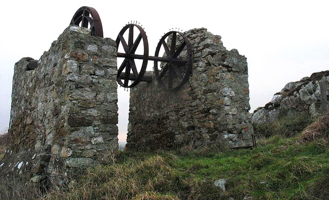
Amlwch Port to Moelfre (12.5 miles) This is the second highest height gain of the total walk. Initially the walk starts in gentle heather terrain, but once you go past Point Lynas it becomes steep, although there are some great views eastwards. This section is a little remote, but ahead are the red sandy expanses of the beaches at Dulas Estuary, Traeth yr Ora and Lligwy. Up on the hill amongst the heathers, as you
leave Amlwch Port, you will pass some old copper bins, which were used to
store the copper ore that was extracted from the ground below. From here the
next main focal point is the
Point Lynas
Lighthouse.
Moelfre to Pentraeth (6 miles) As this section of the walk is shorter than
most, you could take a slight detour off the path just after
leaving Moelfre by walking along the A5105 towards Llanallgo and visit the 3
ancient structures of the
Din Lligwy Hut Group,
Pentraeth to Beaumaris (12.5 miles) This part of the walk takes in a lot of
shoreline walking. You start at sea level at Red Wharf Bay and join the top
of a sea wall for 500 metres, then down some steps to continue to follow the
shoreline. From here you join a lane which eventually takes you onto Bryn
Offa, a heathland owned by the National Trust, and you walk through the
gorse and up and around the prehistoric remains of Bwrdd Arthur Hill Fort
(Arthur's Table),
sat on a limestone plateau. It is thought the main period of occupation here
is the Prehistoric Iron Age but it was also used in Roman times. From up
here you can get views of Red Wharf Bay which you have just left and
also see
Puffin Island
When you arrive at Penmon Point the first
landmark you'll come to is the
Penmon
Lighthouse,
Beaumaris to Llanfairpwll (12.5 miles) Before starting the rest of the walk from
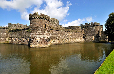
here, take some time out at Beaumaris and take a look at
Beaumaris Castle
Now continuing with the walk, a large part
of this section is on the road, but that doesn't distract from what is on
offer along the way. At the first part, as you approach Menai Bridge, you get
elevated views along the narrowest section of the Menai Strait and across to the mainland and the Snowdonia Hills. At Menai
Bridge there is the
Menai Heritage Experience
From here rejoin the path and continue to follow the route towards Llanfairpwll which next takes you under the
Britannia Bridge,
Once you have got this far it is worth
taking a detour into the village of Llanfairpwll, that became famous in the 1800's as the
village with the Longest Name in the World. Here a visit to
Llanfairpwll Station
Moel y Don to Llyn Rhos-Ddu (7.5 miles) Before returning to Moel y Don to continue
on the path you could stop off at
Plas Newydd
This part of the walk is
probably the flattest section and for the majority of it, it keeps to the Menai Strait. You will be walking through wooded farmland adjoining the
shore, with the Snowdonia Mountains and
Caernarfon Castle
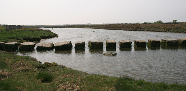
Stepping Stones over the
River Braint
At the point this section joins a road for a second time here, you will first past the Anglesey Sea Zoo and a little further on Foel Farm Park. The road ends at the shore and you continue along the shoreline from here, and when you are almost opposite Caernarfon Castle turn right and over a stile and from here the path leads inland until you reach the River Braint. Follow the River bank until you reach a large set of stepping stones that takes the path across the River at this point to the end of the section at Llyn Rhos-Ddu.
Llyn Rhos Ddu to Aberffraw (13 miles) From this point you will be walking through a National Nature Reserve of dunes, conifer forest and huge beaches as well as farmland and an estuary. Starting from Llyn Rhos-Ddu car park follow the sand track and the waymarked signs alongside Newborough Forest on your right. On your left is Newborough Warren Dunes, so named because of it's past rabbit population. At one time there were 80,000-100,000 rabbits caught here every year, but then in 1959 myxomatosis hit the warren and they were all wiped out. At the end of the forest,
ahead of you is Llanddwyn Bay but just before you get here follow the sign
that takes you into the forest. At the small car park you can turn left and
onto the beach and then follow it round to Llanddwyn Island, or
alternatively you can pass the barrier and follow the track through the
forest until you reach a small roundabout where turning left here, will take
you across to Llanddwyn Island. On the island you can see the remains of a
church, a row of cottages and the two
Llanddwyn Island Lighthouses.
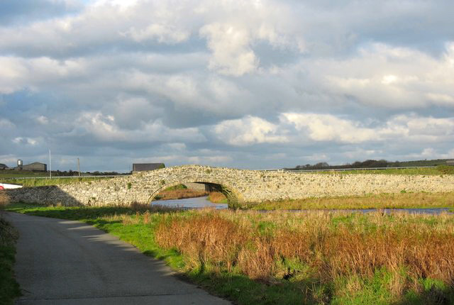
Trace your steps back into the forest and continue to follow the path through the forest until you reach the car park on the road. From here you walk alongside the Malltraeth Estuary and cross the River Cefni into Malltraeth. The sea is kept back from the village by the Malltraeth Cob, an embankment built by Thomas Telford at the end of the 18th century to reclaim farmland, at one time it was the centre of Anglesey's coal mining industry. From here the path goes back along the estuary until a track leads out on the road and into Hermon. Just after the village it turns left to take you back through fields and across to Capel Beulah where at this point you can choose one of two routes. At high tide you can continue along the road and over the old 18th century bridge, that was originally built when horse and carts were becoming more popular on Anglesey, into Aberffraw. Or if the tide permits you can continue across fields through dunes to Traeth Mawr and follow the shoreline and up the River Ffraw estuary into Aberffraw, which during the 7th century, under Rhoderic the Great, to the 13th century, under Llywelyn the Last, was considered the Capital of North Wales.
Aberffraw to Four Mile Bridge (14 miles) This section is the longest piece and highlights the islands sandy beaches. From Aberffraw, once an important port, but now famous for it's impressive sand dunes, which can be as high as 30ft or more, you first take a walk along the top of an embankment parallel with the River Estuary, as the estuary widens the path leads onto the headland at Trwyn Du. From here it then goes down onto the shore at Porth Lleidiog and follows the beach to the other side where it goes onto a cliff edge path following the headland round. At the road which goes back to Aberffraw it again follows the back of a beach at the point where it joins
the causeway to
Llangwyfran Church,
At the next bay, Traeth Llyden, there are two options depending on the tide, one that follows the beach followed by sand dunes and the other which starts on the beach and then through fields to join up with the road into Rhosneigr. Follow the road through the village and head towards the runway of RAF Valley. From here you are now walking along the perimeter fence of the airfield with the sand dunes of Traeth Cymyran and the sea on your left. At the end of the beach follow the field across to Trwyn and Carnau car park and from here follow the edge of the Inland Sea, which separates Holy Island from the Anglesey mainland. Just before Four Mile Bridge there is a sleeper boardwalk to take you over an area of marsh and from here you continue on through the fields and follow the road (B4545) over the Four Mile bridge (only 170 metres!) into Four Mile Bridge village on Holy Island.
Four Mile Bridge to Trearddur Bay (9 miles) We are now on Holy Island. The first part
of this section, from Four Mile Bridge, starts along the shoreline and then
doesn't go near the coast, instead it goes inland through a woodland following
a section of road down to Silver Bay. From here it then follows the coastline
with rocky inlets, sandy coves and a series of striking cliffs in unusual
colours. Up on the headlands you will get panoramic views of Snowdonia,
Caernarfon Bay and Holyhead Mountain, and also Ffynnon Santes Gwenfaen (St
Gwenfaen's Holy Well)
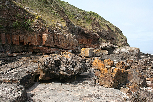
Trearddur Bay to Holyhead (12 miles) This section has the highest point (720ft) of the whole walk as you climb up to the top of Holyhead Mountain, which gives stunning views in all directions. We start the final leg of this walk at the promenade of Trearddur Bay. From here the path travels around the first headland of Porth y Post which has no access on the 10th of December each year. It then follows the road a little before entering Porth Dafarch headland which is owned by the National Trust, the beach here is where divers search for gold from wrecked ships sent by Louis XV. Continue to follow the coast round past Dinas
Island from here there are panoramic views and some interesting rock
formations around Dinas Stack and then on to Porth Ruffydd. At this point
you can take the path that hugs the coast or take the one that heads towards
the Holyhead Mountains, and at the RSPB car park you can then rejoin the path at Gors Goch.
From here follow the path around Abrahams Bosom and onto
Ellins Tower and South Stack Nature Reserve. Once you're ready to rejoin the path, continue
towards the Lighthouse viewpoint. Then continue on the coastal path and
head towards North Stack, but again about half way along you could take
another short detour up towards Holyhead Mountain and take a look at the
Caer y Twr Hillfort.
From
here you're now on the final leg back to Holyhead first going through the
Breakwater Country Park, from here you will see the iconic Holyhead
Breakwater that protects the harbour from the Irish Sea, and down to Porth Namarch before going up some steps
to reach the headland at Ynys Wellt. Continue on round the headland
and then down to the beach and past the end of the Breakwater. Now you have
reached the lane past Porth y Felin bay with it's slipway and moored boats in
the marina, and on to join the Promenade and past the
Maritime Museum.
|
|||||||||||||||||||||||||||||||||||||||||||||||||||||||||||||||||||||||||||||||||||||||||||||||||||||||||||||||||||||||||||||||||||||||||||||||||||||||||||||||||||||||||||||||||||||||||||||||||||||||||||||||||||||||||||||||||||||||||||||||||||||||||||||||||||||||||||||||||||
|
Other
Information Anglesey Walking Festival
Anglesey Books
There are also 2 books available from the Llanfairpwll Tourist Office. These are the Isle of Anglesey Coast Path - Official Guide at £9.99 which includes information on planning the walk such as accommodation, use and frequency of public transport, seasonal closures and tidal restrictions, 12 day walk chapter sections with detailed route description and mapping and notes on points of interest encountered along the way. Also the Guide to the Isle of Anglesey Coastal Path for £1.99 that illustrates the entire route and includes 12 maps. Please let us know any other information that we can add to the Grid(s) or page and any errors that you discover. Before making a long trip to any location it is always wise to double check the current information, websites like magazines may be correct at the time the information is written, but things change and it is of course impossible to double check all entries on a regular basis. If you have any good photographs that you feel would improve the illustration of this page then please let us have copies. In referring to this page it is helpful if you quote both the Page Ref and Topic or Section references from the Grid below. To print the planning grid select it then right click and print the selected area. Please submit information on locations you discover so that this system continues to grow. |
|
||||||||||||||||||||||||||||||||||||||||||||||||||||||||||||||||||||||||||||||||||||||||||||||||||||||||||||||||||||||||||||||||||||||||||||||||||||||||||||||||||||||||||||||||||||||||||||||||||||||||||||||||||||||||||||||||||||||||||||||||||||||||||||||||||||||||||||||||||
. |
|||||||||||||||||||||||||||||||||||||||||||||||||||||||||||||||||||||||||||||||||||||||||||||||||||||||||||||||||||||||||||||||||||||||||||||||||||||||||||||||||||||||||||||||||||||||||||||||||||||||||||||||||||||||||||||||||||||||||||||||||||||||||||||||||||||||||||||||||||
|
|||||||||||||||||||||||||||||||||||||||||||||||||||||||||||||||||||||||||||||||||||||||||||||||||||||||||||||||||||||||||||||||||||||||||||||||||||||||||||||||||||||||||||||||||||||||||||||||||||||||||||||||||||||||||||||||||||||||||||||||||||||||||||||||||||||||||||||||||||
|
|
|||||||||||||||||||||||||||||||||||||||||||||||||||||||||||||||||||||||||||||||||||||||||||||||||||||||||||||||||||||||||||||||||||||||||||||||||||||||||||||||||||||||||||||||||||||||||||||||||||||||||||||||||||||||||||||||||||||||||||||||||||||||||||||||||||||||||||||||||||