Langness Lighthouse
Isle of Man
|

Location Guide |
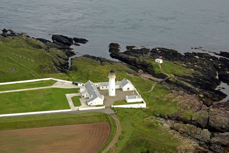
Aerial Photo
Marinas.com
 (more images available) (more images available)
Langness is a slender peninsula hanging from
the south east corner of the Isle of Man. The name means Long Point.
In 1868 a proposal was put to establish a light
at this position because of the large number of wrecks which had taken place and
rapid tides in the area made it a danger to mariners. But the most convincing
argument for a light here was the fact that the two lighthouses on the
Calf
of Man
were inefficient due to their tendency to be covered in fog. Requests
for a lighthouse here were made on 4 occasions over the next 8 years, all
unsuccessful, until in 1874 when tests were carried out on the red light of the
Chicken Rock lighthouse,
and it was found to be unsatisfactory in protecting against the dangers around
Langness. However it was not until 1878 when the building of the lighthouse here
got the go ahead. It was built with a one storey keeper's house and other
buildings enclosed by a stone wall. It came into operation in 1880. It was automated in 1996.
The lighthouse is located on the east side of
Dreswick Point, the southern point of the peninsula, about 1.5 miles south of
Derbyhaven.
British TV personality Jeremy Clarkson owns
much of the surrounding land and has attempted to close access to the
lighthouse, but in May 2010 he was ordered to reopen the traditional pathways
leading to the lighthouse.
Lighthouse information Grid
|
Name: |
Langness Lighthouse, Isle of Man |
|
Current status: |
Working |
|
Geographic Position: |
54° 03.294'N 004° 37.509'W |
|
Grid Reference: |
SC282652 |
|
Ceremonial County: |
Isle of Man
 |
|
Appearance: |
White tower with 77 steps, lantern and
gallery. Tower painted white, watch room buff, lantern black. |
|
Map
Link: |
Multimap
Get a Map
|
|
Aerial photo: |
Marinas.com
|
|
Other photos: |
photo
|
|
Originally built: |
1880 |
|
Current lighthouse built: |
|
|
Height of Tower: |
19 metres |
|
Height of light above mean sea level: |
23 metres |
|
Character of light: |
Flashing (2) White every 30 secs |
|
Character of fog signal: |
|
|
Range of light: |
12 nautical miles |
|
Owned / run by: |
Northern
Lighthouse Board

|
|
Getting there: |
The
lighthouse is located on the east side of Dreswick Point, the southern point
of the peninsula, about 1.5 miles south of Derbyhaven. |
|
Access: |
Site open, tower closed. |
|
Website: |
NLB
|
|
Other Useful Websites: |
Langness - Further
Information
|
| Routes: |
|
|
Other Relevant pages: |
For more articles, lists and other information
see the
Lighthouses Section
Featured list of lighthouses - IOM
 |
|
Notes: |
|
|

|
Please let us know any other information that we
can add to the Grid or page and any errors that you discover. Before making a long trip to any location it is always
wise to double check the current information, websites like magazines may be
correct at the time the information is written, but things change and it is of
course impossible to double check all entries on a regular basis. If you have
any good photographs that you feel would improve the illustration of this page
then please let us have copies. In referring to this page it is helpful if you
quote both the Page Ref and Topic or Section references from the Grid below. To print the
planning grid select it then right click and print the selected area.
Please submit information on locations you discover so
that this system continues to grow.
|