| Home | Newsletter | Locations | Diary |
| Indexes |
|
| Travellers Resource |
|
|
|
|
|
Maps |
|
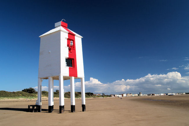
One of three in Burnham-on-Sea
Burnham-on-Sea Low Lighthouse is currently in use as a lighthouse, the other two are not. Burnham-on-Sea is notable for its beach and mudflats, which are characteristic of Bridgwater Bay and the rest of the Bristol Channel ,where the tide can go out for over 1.5 miles (2.4km) and come in far faster then you can run. Burnham is close to the estuary of the River Parrett where it flows into the Bristol Channel, which has the second highest tidal range in the world of 15 metres (49ft), second only to Bay of Fundy in Eastern Canada. The constantly shifting sands have always been a significant risk to shipping and others venturing onto them in the area.
The low wooden pile lighthouse or Lighthouse
on legs is 36ft (11m) high, the light being at 23ft (7m) was built
by Joseph Nelson in 1832, in conjunction with the High Lighthouse to replace
the original Round Tower Lighthouse, which itself had been built to replace
the light kept burning in the tower of St Andrews Church to guide fishing
boats into the harbour. The history of the three lighthouses and the church
tower before them is told at length, including variations to the story in
the location guide on the
Burnham-on-Sea High Lighthouse.
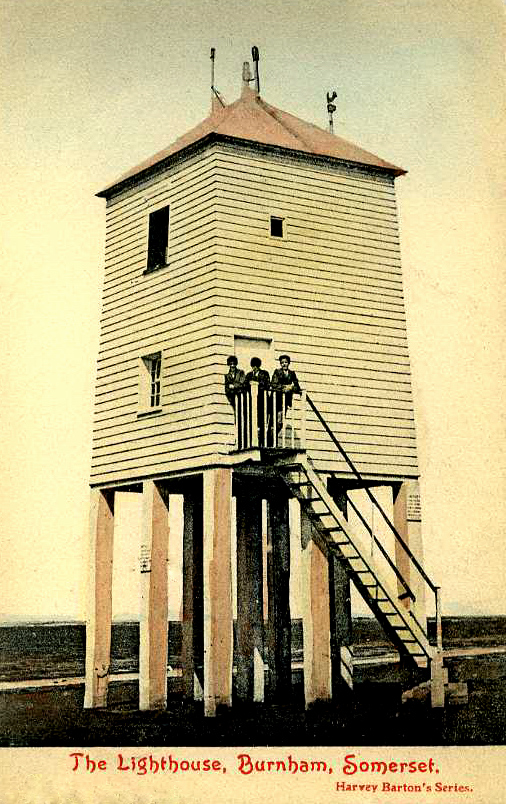
Early Photochrome postcard,
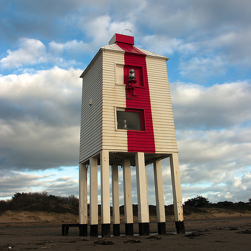
just after 1900, showing the original design and also the steps allow access. The low light is a Grade II listed building. It stands on nine wooden pillars, some with plate metal reinforcement. The structure is whitewashed with a vertical red stripe on the sea side. The lights were inactive between 1969 and 1993 and were re-established when the High Lighthouse lights were permanently discontinued. They have a focal plane of 7 metres (23ft) and provide a white flash every 7.5s plus a directional light (white, red, or green depending on direction) at a focal plane of 4m. It is operated by Sedgemoor District Council. In April 2009, the district council announced plans to restore the historic stairway, which was removed in 1984 due to storm damage, (see old photo above). If visiting please be careful of the treacherous sand and mud flats they may look enticing but stay very near the land connecting part of the beach or you may be another of the people that have to be rescued. But of course that way you may get a hovercraft ride, or if not you won't know about the ride you are taking with the undertaker. It is however perfectly safe to go and take photos of this fine building from the beach. On the beaches on this channel never take or park your car, even when its said to be safe to do so, there are loads of vehicles in this sand and mud, that can swallow them up when the tide comes in far faster than you would expect. Some locals may be able to judge this, but many more are wise enough never to risk it, and more join them each year.
Notice the lamp now fixed to the front by top window
Please let us know any other information that we can add to the Grid or page and any errors that you discover. Before making a long trip to any location it is always wise to double check the current information, websites like magazines may be correct at the time the information is written, but things change and it is of course impossible to double check all entries on a regular basis. If you have any good photographs that you feel would improve the illustration of this page then please let us have copies. In referring to this page it is helpful if you quote both the Page Ref and Topic or Section references from the Grid below. To print the planning grid select it then right click and print the selected area. Please submit information on locations you discover so that this system continues to grow.
|
||||||||||||||||||||||||||||||||||||||||||||||||||||
. |
||||||||||||||||||||||||||||||||||||||||||||||||||||
|
||||||||||||||||||||||||||||||||||||||||||||||||||||
|
|