Port Erin Lighthouse
Port Erin, Isle of Man
|

Location Guide |
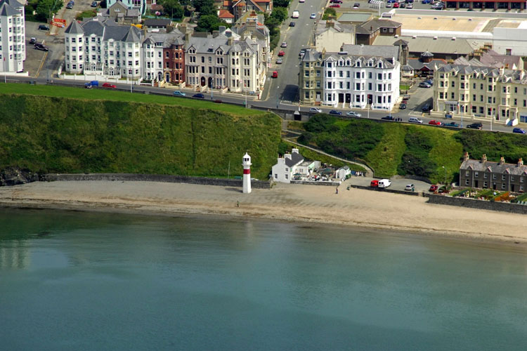
Aerial Photo
Marinas.com
 (more images available) (more images available)
This is Port Erin range Front
harbour light, located on the Beach. The rear light is on a streetlight
style pole, also coloured red and white, up on the road behind it.
Lighthouse information Grid
|
Name: |
Port Erin Lighthouse, on Port Erin Beach, Isle of Man |
|
Current status: |
Working |
|
Geographic Position: |
54° 5' 14.1" N 4° 45' 33.9" W |
|
Grid Reference: |
SC196692 |
|
Ceremonial County: |
Isle of Man
 |
|
Appearance: |
concrete tower with lantern, tower painted white with a single red
horizontal band |
|
Map
Link: |
Multimap
|
|
Aerial photo: |
Marinas.com
|
|
Other photos: |
view
rear light
|
|
Originally built: |
|
|
Current lighthouse built: |
|
|
Height of Tower: |
11
m |
|
Height of light above mean sea level: |
10
m |
|
Character of light: |
continuous red light |
|
Character of fog signal: |
|
|
Range of light: |
|
|
Owned / run by: |
Isle of
Man Harbours
|
|
Getting there: |
|
|
Access: |
Site open, tower closed |
|
Website: |
|
|
Other Useful Websites: |
|
| Routes: |
|
|
Other Relevant pages: |
For more articles, lists and other information
see the
Lighthouses Section
Featured list of lighthouses - IOM
 |
|
Notes: |
|
|

|
Please let us know any other information that we
can add to the Grid or page and any errors that you discover. Before making a long trip to any location it is always
wise to double check the current information, websites like magazines may be
correct at the time the information is written, but things change and it is of
course impossible to double check all entries on a regular basis. If you have
any good photographs that you feel would improve the illustration of this page
then please let us have copies. In referring to this page it is helpful if you
quote both the Page Ref and Topic or Section references from the Grid below. To print the
planning grid select it then right click and print the selected area.
Please submit information on locations you discover so
that this system continues to grow.
|