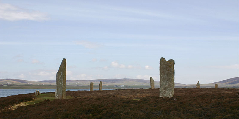
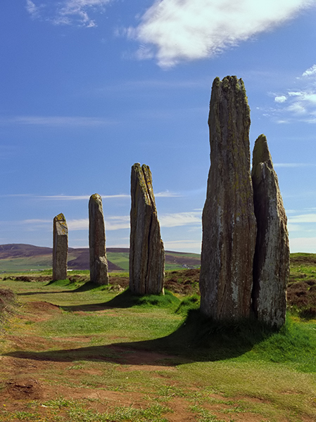
Ring of Brodgar Stone Circle
Orkney, Scotland
|

Featured Location Guide |
Ring of Brodgar (or Brogar) –(pronounced broa(d)yeurA)
60 stone ring of which 27 are still standing.
"A part of the World
Heritage Site - Heart of Neolithic Orkney"
| This is a Neolithic henge and stone circle in Orkney, Scotland. The ring of
stones stands on a small strip of land between the Lochs of Stenness and Harray.
The centre of the circle has never been excavated by archaeologists and
scientifically dated, but by comparison with
Stonehenge
and many other ancient
sites in the British Isles and Europe, it is considered broadly contemporary,
constructed around 2500 BC. The true circle is 104 metres in diameter, and the third largest in the
United Kingdom. It is beaten only by the outer ring of stones at
Avebury,
Wiltshire and the Greater Ring at Stanton Drew,
Somerset. The Brodgar ring is
said to be exactly the same size as Avebury's two inner rings, but the meaning
of this is not clear.
The henge originally comprised of 60 stones, of which only 27 remained standing
at the end of the 20th century. The stones are set within a circular ditch up to
3 metres deep and 9 metres wide that was carved out of the solid bedrock by the
ancient residents. It has two entrance causeways, one to the north-west and the
other to the south-east.
The stones vary in height from 2.1 metres (7 feet) to a maximum of 4.7 metres
(15ft 3in).
 
|
 |
|
In 1792, the ring contained 18 standing stones, with eight
lying prone. But by 1815, an account shows that two more stones had been
toppled, leaving only 16 erect. Then, in 1854, in what was the first detailed
account of the stone circle, there were only 13 erect stones, ten complete, but
fallen, stones and fragments of 13 more. The Ring o' Brodgar was taken into
state care in 1906 and two years later, most of the fallen stones were placed
back in what was thought to be their original sockets. Since then two stones
have suffered lightning strikes, leaving 27 standing today.
|

See here for Picture Details
 |
The stone circle is practically in the centre of a massive natural "cauldron"
formed by the hills of the surrounding landscape, accentuated by the water of
the lochs. The site is, therefore, bordered by hill, water and sky.
The surrounding area is full of other standing stones and round piles of
earth a top prehistoric tombs, making a significant historic landscape. Although
its exact purpose is not known, the proximity of the Standing Stones of Stenness
and its Maeshowe tomb make the Ring of Brodgar a site of major importance.
Excavations by Orkney College at the nearby Ness of Brodgar site between the
Ring and the Stones of Stenness have uncovered several buildings, both ritual
and domestic and the works suggest there are likely to be more in the vicinity.
Pottery, bones, stone tools and a polished stone mace head have also been
discovered. Perhaps the most important find is the remains of a large stone wall
which may have been 100 metres long and up to 6 metres high. It appears to
traverse the entire peninsula the site is on and may have been a symbolic
barrier between the ritual landscape of the Ring and the mundane world around
it.
1 mile NNE of
Stenness
Stone Circle

Click on
Images to see a larger version
.
Planning Grid
|
Location: |
Ring of Brodgar Stone Circle, Nr
Finstown, Orkney, Scotland |
|
Grid Reference: |
HY294133 |
|
Getting there: |
Just off the B9055,
Left, just north of Brodger, about a mile NNE of the Staines of
Stenness |
|
Access: |
Open |
|
Parking: |
Parking place/layby, by
side of road |
|
Facilities: |
None |
|
Things To Do,
See and Photograph: |
|
|
What to take: |
|
|
Nature highlights: |
Located in a wildlife
area known for 'tit' birds. |
|
Address: |
Nr
Finstown
Orkney
Scotland |
|
Postcode: |
|
|
Telephone: |
|
|
Opening times: |
Open all the time |
|
Charges: |
None |
|
Photo Restrictions: |
None |
|
Other Restrictions: |
None |
|
Special Needs Access: |
|
|
Special Needs Facilities: |
|
|
Children Facilities: |
|
|
Dogs Allowed: |
|
|

|
Please let us know any other information that we
can add to the Further information and Planning Grids or page and any errors that you discover. Before making a long trip to any location it is always
wise to double check the current information, websites like magazines may be
correct at the time the information is written, but things change and it is of
course impossible to double check all entries on a regular basis. If you have
any good photographs that you feel would improve the illustration of this page
then please let us have copies. In referring to this page it is helpful if you
quote both the Page Ref and Topic or Section references from the Grid below. To print the
planning grid select it then right click and print the selected area.
Please submit information on locations you discover so
that this system continues to grow.
|