| Home | Newsletter | Locations | Diary |
| Indexes |
|
| Travellers Resource |
|
|
|
|
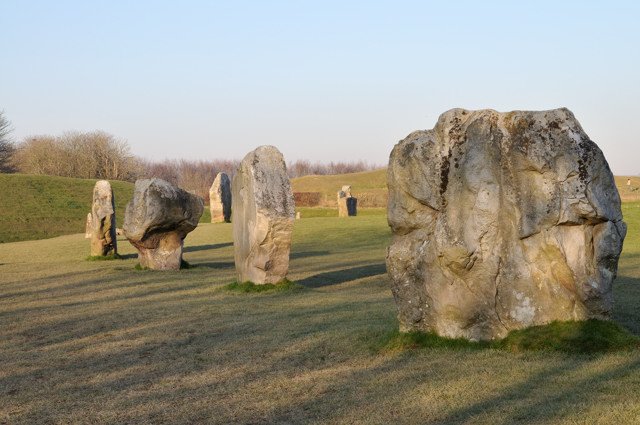
The largest stone circle in Europe, some say the world. A world heritage site.
English Heritage say "..... the largest, most impressive and complex prehistoric site in Britain. Built and altered over many centuries from about 2850BC to 2200BC". The Great circle consisted of 200 standing stones, comprising an outer and two inner circles and a cove. It is surrounded by a massive bank and ditch (henge). The circle is 427m (1400ft) in diameter, about a mile round and covers an area of 11.5ha (28 acres). The outer bank, still very impressive, was originally 17m (55ft) high from ditch bottom to bank top, its now about half this size. Today we notice the stones, but when built with white chalk banks and ditches they would not have been as obvious and probably not visible from outside the bank. Early histories talk of a single very much taller stone being present, which has since been lost, so today we have no real idea as to why this was built. In the 1930's the site was excavated by Alexander Keiller who also re-fracted many of the stones. The stones vary in size some weighing it is thought as much as 40 to 60 tons, with most over 20 tons. They were left rough and not dressed as were the Stonehenge blocks. Most come from on the nearby Marlborourgh Downs, but it was no slight task to move them the distance involved. It is thought that the building took several hundred years and took place about 4,500 years ago. 27 stones are in place today, giving some complete sections but also many sections missing. Over time some were taken for building and some were destroyed, many of the stones were broken up by lighting fires beneath them and pouring cold water over them. Some of it is thought to have been used to construct the present village, it would have been easier to have collected fresh stone which is on the surface and available nearby, some of the stones were also buried. This destruction was by Christians, fearing the power or influence of the stone circle in an age of superstition. You can walk amongst the stones, touch them and even climb onto a few. You can have picnics or hold any ceremony you like amongst them. To the south/south west, starting just across the road is an avenue, two rows of stones leading to The Sanctuary 2.5km (1.5miles) away, located at the junction of the A4 and Ridgeway Path. You can walk along this for a part of the route. The Sanctuary is a less impressive site to visit having a number of rows of coloured markers, marking postholes that have been discovered. About a mile to the south is Silbury Hill, a large mostly man made earth mound, the largest man made prehistoric mound in Europe, with no known purpose, and across the A4 and a couple of fields further away is the West Kennet Longbarrow, the finest example of a longbarow known. This is large enough for you to walk in and explore the chambers. To the north/north east is Windmill Hill with earth works/barrows etc. to the east is a path up to the Ridgeway Path. West of Avebury, the Iron Age earthwork of Oldbury Castle crowns Cherhill Down, along with the Lansdowne Monument and White Horse on the hillside. In fields around are other stones, and some suggest there were other avenues, one proven, and that field working markers around the hillsides and hill forts within walking distance put this as the centrepiece of an early civilisation. The Alexander Keiller Museum is not large, but with many of the archaeological finds of the site it is worth visiting. The dovecote is 16th-century, while the thatched threshing barn and stables are 17th-century. The thatched pub (the Red Lion) that sits in the centre of the circle serves meals, and found while doing some work, a well thought to predate the pub building now able to be seen in one of its dining rooms, and thought by some to have been the original centrepiece and a part of the circle complex.
.
Please let us know any other information that we can add to the Further information and Planning Grids or page and any errors that you discover. Before making a long trip to any location it is always wise to double check the current information, websites like magazines may be correct at the time the information is written, but things change and it is of course impossible to double check all entries on a regular basis. If you have any good photographs that you feel would improve the illustration of this page then please let us have copies. In referring to this page it is helpful if you quote both the Page Ref and Topic or Section references from the Grid below. To print the planning grid select it then right click and print the selected area. Please submit information on locations you discover so that this system continues to grow.
|
||||||||||||||||||||||||||||||||||||||||||||||||||||||||||||||||||||||
. |
||||||||||||||||||||||||||||||||||||||||||||||||||||||||||||||||||||||
|
||||||||||||||||||||||||||||||||||||||||||||||||||||||||||||||||||||||
|
|