Hay Inclined Plane
Coalport, Shropshire
|

Location Guide
 |
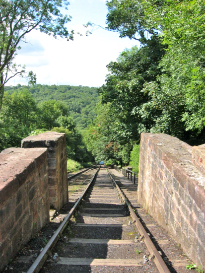
The Hay Inclined Plane is currently the most
complete remains of an inclined plane in Britain.
| It lifted boats through 63 metres (207ft), a height that
would normally be achieved by using 25 locks. It operated from 1792 to 1894, before falling into disuse and decay. The original rails were removed in
1910 and the canal basin filled in during the 1920s.
Restoration work started in 1969, continuing
later with the re-laying of the railway tracks and the clearance of the
canal basin.
Brief history of inclined planes
The idea of using inclined planes to move boats
over obstacles or between water levels dated back to the Greeks in 600BC, but it
was the late 1700's that saw it first becoming of interest in Britain, with
a first recording I can find of a suggestion to use being in 1773, in Cornwall on
the St Columb Canal at Lusty Glaze joining the canal to the sea. In 1788 an
inclined plane was used for the first time in England to raise a boat on the Ketley
Canal in Shropshire,
Wikipedia, and was in use for 28 years.
The Ketley Canal joined the Shropshire Canal
and nearby, in 1792, another inclined plane was opened linking the Shropshire
Canal at Blists Hill Down to the River Severn or a canal at Coalport that joined
the Severn. There are slightly different accounts. This is now known as the Hay
Inclined Plane, the one we are looking at on this page. |
 |
The Hay Inclined Plane, lifted and lowered
boats 63m using a combination of steam power and gravity.
Good views of this inclined plane can be had
from the bottom at Coalport. It is also well worth the walk to the end of the
canal at Blists Hill to see the remains of the basin and the base of the steam
winding engine at the top.
The canal at the top, other parts nearby and
the inclined plane can be visited as part of the Blists Hill Victorian Town,
part of the Ironbridge visitor attractions. During 2009 a new incline plane is
being created, very similar in design to the Hay Incline and this new one will
be fully functional and able to be ridden on.
The
Blists
Hill Open Air Museum
 is well worth a
visit but you need at least half a day to see it. Within it you will find a
Victorian town, industry, a beam engine and far more. is well worth a
visit but you need at least half a day to see it. Within it you will find a
Victorian town, industry, a beam engine and far more.
A free bus service operates around the various
attractions for passport ticket holders.
Telford Connect Bus Service,
PDF leaflet and timetable.
The FREE Entry Route
The Ordnance Survey map also shows a public
right of way running up the side of the inclined plane that's is labelled as the
Monarchs Way, and South Telford Heritage Trail which is a walking route
visiting many remains around the area including the inclined plane by going
along this path.
Click this button to see more views of the Inclined
Plane and surroundings
Please let us know any other information that we
can add to the Grid(s) or page and any errors that you discover. Before making a long trip to any location it is always
wise to double check the current information, websites like magazines may be
correct at the time the information is written, but things change and it is of
course impossible to double check all entries on a regular basis. If you have
any good photographs that you feel would improve the illustration of this page
then please let us have copies. In referring to this page it is helpful if you
quote both the Page Ref and Topic or Section references from the Grid below. To print the
planning grid select it then right click and print the selected area.
Please submit information on locations you discover so
that this system continues to grow.
|
