Stanes of Stenness Stone Circle
Orkney, Scotland
|
![](../../../../symbols/key/icons/featured16.GIF)
Featured Location Guide |
"A part of the World
Heritage Site - Heart of Neolithic Orkney"
![](../../../../images/A_heritage/ancient/stone_circles/stenness/Stenness_small.jpg) ![](../../../../symbols/cc/icons/ccs.png) ![See Larger Image](../../../../symbols/key/icons/magnify-clip.png)
See here for Picture Details
![](../../../../symbols/key/icons/link10.gif)
Click on
Images to see a larger version
The stones are thin slabs, approximately 300mm (1ft) thick. Four, up to
about 5m (16ft) high, were originally elements of an elliptical shaped
stone circle of 12 stones, about 32m (104ft) diameter, on a levelled
platform of 44m (144ft) diameter. The circle was surrounded by a
rock-cut ditch 2m deep, 7m wide and 44m in diameter which has become
filled-in over the years. It is surrounded by an earth bank, with
a single entrance causeway on the north side. The entrance faces towards
the Neolithic Barnhouse Settlement which has been found adjacent to the
Loch of Harray. The Watch Stone stands outside the circle to the
north-west and is 5.6m (18ft) high.
Excavation has revealed a square setting of
stones and bedding holes for further uprights, either stone or wooden.
Other smaller stones include a square stone
setting in the centre of the circle platform where cremated bone, charcoal and
pottery were found, and animal bones were found in the ditch. The pottery links
the monument to Skara Brae and Maeshowe, and the site is thought to date from at
least 3000BC.
Even in the 18th century the site was
still associated with traditions and rituals, by then relating to Norse
Gods. It was visited by Walter Scott in 1814. Other antiquarians
documented the stones and recorded local traditions and beliefs about
them. One stone, known as the "Odin Stone" was pierced with a circular
hole, and was used by local couples for plighting |
![](../../../../images/A_heritage/ancient/stone_circles/stenness/Standing-Stones-of-Stenness.jpg)
![](../../../../symbols/cc/icons/ccs.png) ![See Larger Image](../../../../symbols/key/icons/magnify-clip.png)
|
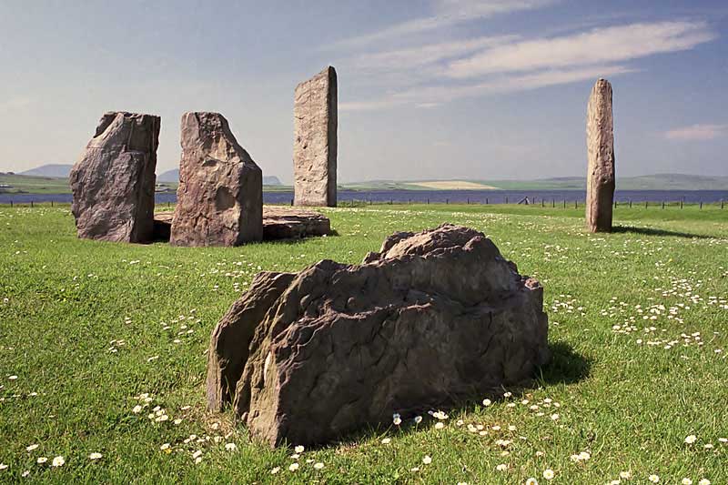
engagements by
holding hands through the gap. It was also associated with other ceremonies
and believed to have magical power.
In December 1814 Captain W. Mackay, a
recent immigrant to Orkney who owned farmland in the vicinity of the stones,
decided to remove them on the grounds that local people were trespassing and
disturbing his land by using the stones in rituals. He started in December
1814 by smashing the "Odin Stone".
This caused outrage and he was stopped after
destroying one other stone and toppling another. The toppled stone was
re-erected in 1906 along with some inaccurate reconstruction inside the circle.
However, even the few stones that have survived are said to create a powerful
atmosphere hinting at the distant past. As to the destroyed stone, apparently
the part with the hole was used as the pivot for a horse mill but was destroyed
after World War II.
It is sited on a promontory at the south bank
of the stream that joins the southern ends of the sea loch 'Loch of Stenness'
and the freshwater loch 'Loch of Harray'. The name, pronounced stane-is,
comes from Old Norse meaning 'stone headland'. The stream is now bridged, but at
one time was crossed by a stepping stone causeway, and the
Ring of Brodgar
lies about 1.2 km (3/4 mile) away to the north-west, across the stream and near
the tip of the isthmus formed between the two lochs.
Maes Howe
chambered cairn is about
1.2 km (3/4 mile) to the east of the Standing Stones of Stenness and several
other Neolithic monuments also lie in the vicinity, suggesting that this area
had particular importance.
Information on alignments of some other nearby
stones can be found at
http://www.maeshowe.co.uk/maeshowe/standing.html.![](../../../../symbols/key/icons/link10.gif)
Click on
Images to see a larger version
.
Planning Grid
Location: |
Stenness Stone Circle, Near Finstown, Orkney, Scotland |
Grid Reference: |
HY307125 |
Getting there: |
Immediately east of B9055, and well
signposted. |
Access: |
Road side |
Parking: |
On road or provided parking |
Facilities: |
None |
Things To Do,
See and Photograph: |
Stone circle, a range of stone circles and
other sites are in the area |
What to take: |
|
Nature highlights: |
There is significant bird life present in the
lochs on either side of this site. About two miles to the south is the Burn
of Ayreland as it discharges to the Clestrain Sound. |
Address: |
|
Postcode: |
|
Telephone: |
|
Opening times: |
All the time |
Charges: |
Free entry |
Photo Restrictions: |
none |
Other Restrictions: |
none |
Special Needs Access: |
|
Special Needs Facilities: |
|
Children Facilities: |
|
Dogs Allowed: |
|
|
![](../../../../images/Locations/help/Side_Banner.jpg)
|
Please let us know any other information that we
can add to the Further information and Planning Grids or page and any errors that you discover. Before making a long trip to any location it is always
wise to double check the current information, websites like magazines may be
correct at the time the information is written, but things change and it is of
course impossible to double check all entries on a regular basis. If you have
any good photographs that you feel would improve the illustration of this page
then please let us have copies. In referring to this page it is helpful if you
quote both the Page Ref and Topic or Section references from the Grid below. To print the
planning grid select it then right click and print the selected area.
Please submit information on locations you discover so
that this system continues to grow.
|