Cirencester Amphitheatre
Cirencester, Gloucestershire
|

Featured Location Guide |
The earthwork remains of one of the largest
Roman amphitheatres in Britain, built in the early 2nd century. It served the
Roman city of Corinium (now Cirencester), then second only in size and
importance to London, and had a capacity of around 8,000 spectators. Later
fortified against Saxon invaders.

Corinium Dobunnorum known today as
Cirencester was the second largest town in the Roman province of Britannia,
which is believed to have had a population of around 15,000 at the time. A roman
fort was established about a year after the Roman conquest and continued as a
local centre until early 60AD, however it appears to have been abandoned by the
military by the mid 70's and it became a capital instead. A street grid was laid
out and a large number of stone buildings, two market places, shops and private
houses were established and this development continued until the 4th century.
The town was fortified in the late 2nd century with five access gates and
polygonal towers. No public baths have been found in Cirencester however there
is evidence of a system of wooden water pipes which could indicate there was an
aqueduct at some point.
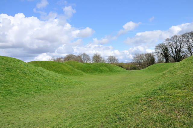
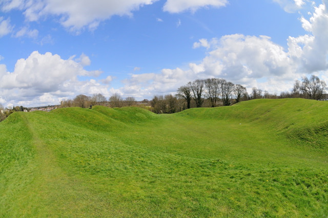
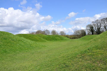
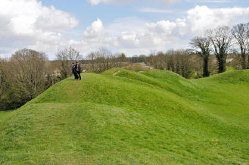
The amphitheatre stands to the south-east of
the town and was built on the site of an old quarry. Stone walls were added in
the early 2nd century, but there are no sign of these today. It is believed that
they collapsed and the complex was largely rebuilt to include small chambers
around the circuit, it is not know what they would have been used for, but
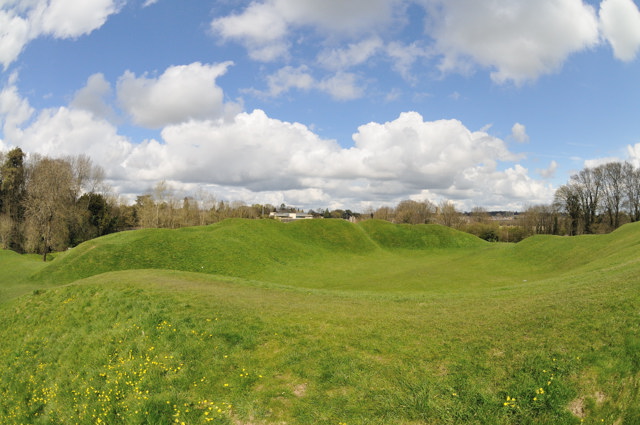
suggestions include animal or convict cells or small shrines. The two curving
mounds enclose a central area which would have been used for shows and
entertainment, on these mounds originally would have been planking and dry stone
walls supporting the wooden seating for spectators. Originally the seating banks
would have been 10 metres high, had tiered seats with an area behind for
standing spectators. An estimated 8,000 or more people it is believed could have
been accommodated.
 |
 |
 Click on images to see
larger version
Click on images to see
larger version |
 |
 |
|
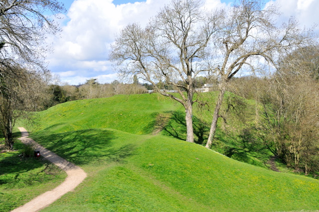
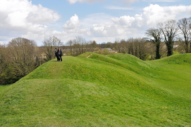
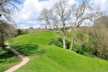
For all the above, which show different views from around the
amphitheatre site. The top left being the path from the road into the
middle of the amphitheatre. |
The amphitheatre today is looked after by
English Heritage although there is free access to all. In fact it is a
thoroughfare for locals to get to the town centre and to walk their dogs. It is
known locally as the 'Bull Ring' thought to have come about from it's use in the
18th century for bull-baiting contests.
Finding the amphitheatre can be a challenge. It
is signposted with a single brown tourist sign from the dual carriage way, the
A419, that goes around the town. You need to be heading away from town out on
the A419 to Stroud and take the road on the left into Chesterton Lane (now the
signs end) follow this road down to a fork, take Cotswold Avenue on the left
after a few large road humps and houses on both sides the amphitheatre is on
your left. You can park in Cotswold Avenue and walk into the Amphitheatre from
here.
Once there although at first sight appears to
be grass mounds, it is impressive the height of the mounds are large, when stood
in the centre you get the feeling of the crowds around you and get an idea of
what it must have felt like for those taking part. On top of the mounds you can
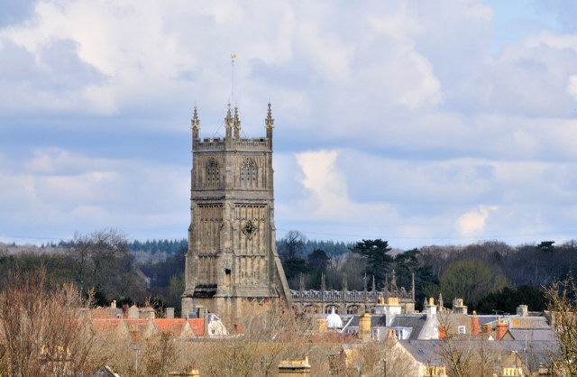
see views over to Cirencester town itself and the spire of the church.
Cirencester is also a nice market town to visit.
.
Planning Grid
|
Location: |
Cirencester Amphitheatre, Cirencester,
Gloucestershire |
|
Grid Reference: |
SP019013 |
|
Getting there: |
Off the A419 heading out of Cirencester
towards Stroud. Take the road on your left into Chesterton Lane (brown
tourist sign here), follow this road down to a fork, take Cotswold Avenue on
the left then after a few large road humps and houses on both sides, the
amphitheatre is on your left. |
|
Access: |
From Cotswold Avenue through a gate. |
|
Parking: |
No restrictions within Cotswold Avenue |
|
Facilities: |
None |
|
Things To Do,
See and Photograph: |
Amphitheatre mounds, views of Cirencester from
top of mounds. |
|
What to take: |
|
|
Nature highlights: |
|
|
Address: |
|
|
Postcode: |
GL7 |
|
Telephone: |
01452 396572 |
|
Opening times: |
All year |
|
Charges: |
Free access |
|
Photo Restrictions: |
None |
|
Other Restrictions: |
None |
|
Special Needs Access: |
small tarmac/grit path before you are on
grass, which is relatively flat ground. |
|
Special Needs Facilities: |
None |
|
Children Facilities: |
Lots of open space to run around in |
|
Dogs Allowed: |
Yes |
|

|
Please let us know any other information that we
can add to the Further information and Planning Grids or page and any errors that you discover. Before making a long trip to any location it is always
wise to double check the current information, websites like magazines may be
correct at the time the information is written, but things change and it is of
course impossible to double check all entries on a regular basis. If you have
any good photographs that you feel would improve the illustration of this page
then please let us have copies. In referring to this page it is helpful if you
quote both the Page Ref and Topic or Section references from the Grid below. To print the
planning grid select it then right click and print the selected area.
Please submit information on locations you discover so
that this system continues to grow.
|