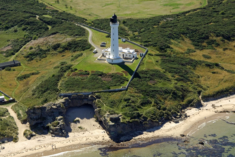
Covesea Skerries
Lighthouse
aka Lossiemouth
Lighthouse
Lossiemouth, Morayshire
|

Location Guide |
Aerial Photo
Marinas.com
 (more images available) (more images available)
Also known as the Lossiemouth
Lighthouse, it stands 161ft above water. The Keeper's houses and other light
station buildings are preserved, and the original light keepers residences are
available for
self-catering holiday accommodation.
There were many applications made for a light to
be established at this point along with Tarbet Ness following the loss of 16
vessels during a storm in November 1826. Initially it was agreed to establish a
lighthouse on Craighead, a pyramid of pillars went up in 1845 and in 1846 the
light was shown from this lighthouse. Initially it was surrounded by high walls
to give shelter to the other buildings on site, but this caused 'strong
whirlwinds' and it made it difficult for the lightkeeper to work from his
lookout, so in 1907 a start was made to lower the walls so they had less impact.
It was automated in 1984.
The skerries are small rocky islands
off the south coast of the Moray Firth, but the lighthouse is located on the
mainland near the islands, about 3 miles west of Lossiemouth, just off the coastal
road B9040.
|
Lighthouse information Grid
|

|
Please let us know any other information that we
can add to the Grid or page and any errors that you discover. Before making a long trip to any location it is always
wise to double check the current information, websites like magazines may be
correct at the time the information is written, but things change and it is of
course impossible to double check all entries on a regular basis. If you have
any good photographs that you feel would improve the illustration of this page
then please let us have copies. In referring to this page it is helpful if you
quote both the Page Ref and Topic or Section references from the Grid below. To print the
planning grid select it then right click and print the selected area.
Please submit information on locations you discover so
that this system continues to grow.
|