Les Hanois Lighthouse
Guernsey
|

Location Guide |
The Hanois Lighthouse rises from a rocky reef
on the south west side of the Island, and takes its name from the group of rocks
- Les Hanois. It marks the western end of the Channel Islands as well as
providing a position fix for vessels entering the Channel Traffic Separation
Scheme.
Hanois Lighthouse is important in the
development of lighthouse engineering, because it was the first to be built with
granite blocks interlocking both vertically and laterally. Various methods of
jointing the stones in rock towers have been employed but was James Douglass who
suggested that the stones might be dovetailed together both laterally and
vertically. The cement mortar in the joint locks the dovetails so that the
stones cannot be separated without being broken. This method was first employed
at the Hanois Lighthouse, and it became the pattern for all sea rock towers.
A helideck was constructed above the lantern in
1979. Automation work began in July 1995 and the station became unwatched in
January 1996. The station was converted to solar power with panels mounted
around the lower part of the helideck support structure.
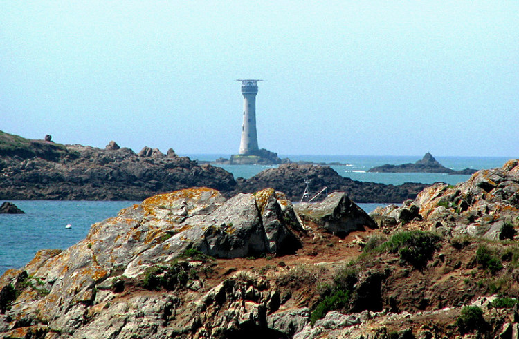
 Photo by
Graham and Dairne
Photo by
Graham and Dairne

Lighthouse information Grid
|
Name: |
Les Hanois
Lighthouse, Guernsey |
|
Current status: |
Currently in use |
|
Geographic Position: |
49
26.2 N 02 42.1 W |
|
Grid Reference: |
|
|
Ceremonial County: |
Guernsey

|
|
Appearance: |
tapered granite tower incorporating keeper's quarters, with lantern,
gallery, and a helipad above the lantern. Lighthouse painted white. |
|
Map
Link: |
|
|
Aerial photo: |
|
|
Other photos: |
photo
view from the mainland
closeup
|
|
Originally built: |
1862 |
|
Current lighthouse built: |
|
|
Height of Tower: |
33
Metres |
|
Height of light above mean sea level: |
33
Metres |
|
Character of light: |
White Group Flashing Twice Every 13 Seconds |
|
Character of fog signal: |
Sounding Twice Every 60 Seconds |
|
Range of light: |
20
nautical miles |
|
Owned / run by: |
Trinity House
 |
|
Getting there: |
|
|
Access: |
|
|
Website: |
|
|
Other Useful Websites: |
|
| Routes: |
|
|
Other Relevant pages: |
For more articles, lists and other information
see the
Lighthouses Section
Featured list of
Lighthouses - Channel
Islands
 |
|
Notes: |
|
|

|
Please let us know any other information that we
can add to the Grid or page and any errors that you discover. Before making a long trip to any location it is always
wise to double check the current information, websites like magazines may be
correct at the time the information is written, but things change and it is of
course impossible to double check all entries on a regular basis. If you have
any good photographs that you feel would improve the illustration of this page
then please let us have copies. In referring to this page it is helpful if you
quote both the Page Ref and Topic or Section references from the Grid below. To print the
planning grid select it then right click and print the selected area.
Please submit information on locations you discover so
that this system continues to grow.
|