| Home | Newsletter | Locations | Diary |
| Indexes |
|
| Travellers Resource |
|
|
|
|
|
||||||||||||||||||||||||||||||||||||||||||||||||||||||||||||||||||||||||||||
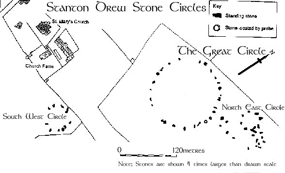
| As well as showing better, the position of some of the stones which are no longer on the surface, they also discovered post-hole rings inside the main circle. They indicate that once there was a massive timber henge or building here. It has nine concentric rings of what look like postholes, each about three feet wide. The outermost ring is more than 300 feet in diameter, filling most of the area within the Great Circle, while the innermost ring is about 75 feet across. All told, there were probably between 400 and 500 posts. Beyond the stones the magnetometer located an encircling ditch, no longer visible, about 23 feet wide and almost 450 feet in diameter. The south west circle also had 3 rings of post holes running within it. |
 |
The site is suggested to be aligned on the river, and at some times of the year this floods and then often the river runs red, with clay leaching into it.
The great circle has its own magnetic field, and this can be seen using a compass, this has led some to believe that these monuments were more than observatories but did something with, or was connected with, energy flow. At the time they were built the magnetic effects of the earth would have been many times stronger than they are today. Many also report this ring having one of the strongest effects on dowsing rods, these are not made of magnetic responsive material so not in theory simply affected by the magnetic field that has been created.
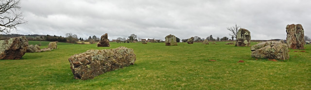
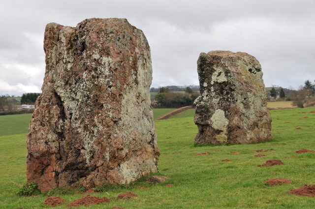
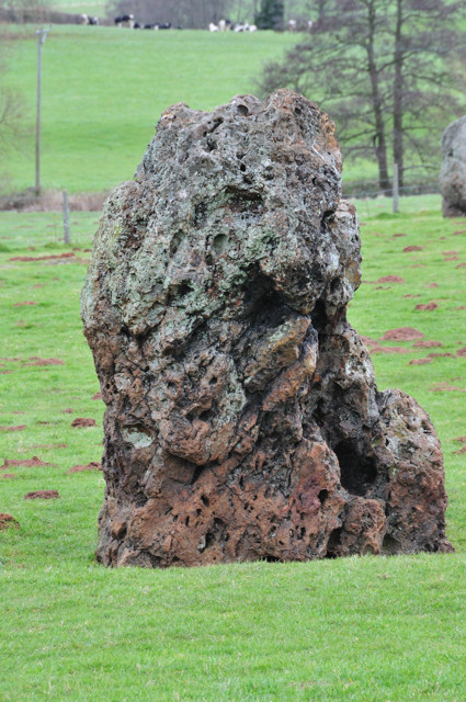
On one visit, there were no other visitors at first, but we were closely followed by a couple from Holland and as we were leaving another car pulled up by the side of us. It was a very interesting site to see and worth a visit if you like stone circles, you will not be disappointed. On our latest visit we saw no one else. This is probably the finest stone rings in Britain, so near a major city, far more complete and original but known by fewer people.
|
History and Folklore Although there is not much recorded evidence of them, they are thought to have been first noted by an antiquarian called John Aubrey in 1664. However the first plan of them was not published until 1776 by William Stukeley. Very little is known about the site and in it's absence folklore has been allowed to grow up around them. The most persistent tale is that of a Wedding Party. Where it is said that the stone circles and cove are the petrified remains of a wedding party turned to stone by the Devil for dancing on the Sabbath. The cove is supposed to represent the parson and bride and groom with the other circles being the remains of the guests. The story goes that one Saturday, a long time ago, there was a wedding feast on the site of the existing circles and everybody who attended was having a good time. When the clock struck midnight the fiddler refused to play anymore because it was Sunday. The bride was not having any of this and insisted the party would go on even if she had to find another fiddler. A tall dark man with a fiddle appeared and struck up a tune. He played faster and faster and the guests were compelled to keep going. This apparently went on all night until the early hours of the morning when the group had turned to stone and the Devil had disappeared with their souls. Of course there had to be one survivor of this tale for it to have been told in the first place, and it is said that the original fiddler was found that Sunday morning cowering in the field with fright after what he had seen happen the night before. Similar Sunday observance stories relate to many stone circles, put about when the fear of God was widely taught by Christians. |
|
A second tradition is that the stones are uncountable. It is said that anybody who tried to count the stones would either die on the sport or become ill soon afterwards. (I have found no record of this though).
Further confusion
It is often said that Stanton Drew was lucky,
being tucked away from public gaze it was not subject to the same vandalism from
Christian groups as some other lowland monuments, it is largely complete, the
finest original example that we have, and with some features still functioning.
While with Avebury
![]() for example many of the stones were destroyed and others
buried and it was only in the 1930's that it was restored and many stones put
back. There is no such record of any similar restoration at Stanton Drew.
So how can we explain that when Aubrey visited Stanton Drew in the summer
of 1664, he recorded that many of the stones had been removed and smashed
during the previous few years by farmers wishful of extra land, and was
unable to reach the stones because the field was full of ripening corn. So does
this mean that there were other circles beyond what we can see now, or could
there be another explanation.
for example many of the stones were destroyed and others
buried and it was only in the 1930's that it was restored and many stones put
back. There is no such record of any similar restoration at Stanton Drew.
So how can we explain that when Aubrey visited Stanton Drew in the summer
of 1664, he recorded that many of the stones had been removed and smashed
during the previous few years by farmers wishful of extra land, and was
unable to reach the stones because the field was full of ripening corn. So does
this mean that there were other circles beyond what we can see now, or could
there be another explanation.
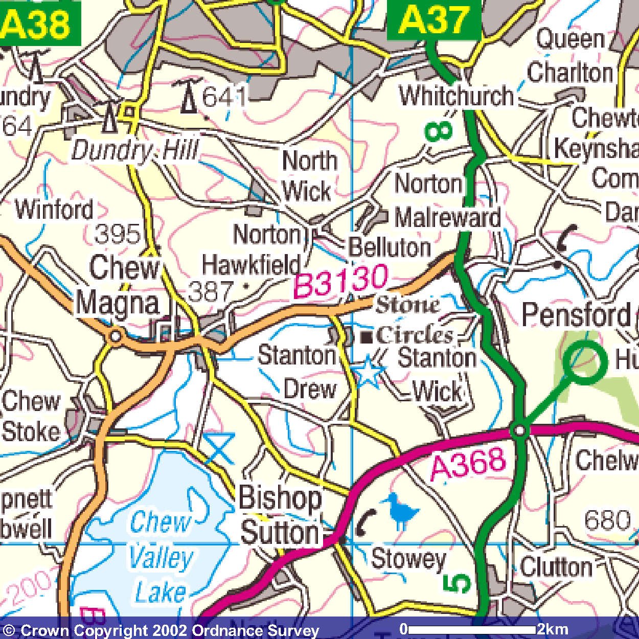
This map shows the position of the stones within the surrounding area
See the
circles in our
![]()
See Also:
The discussion on the purpose of stone circles
![]()
Stanton Drew Stone Circle Gallery
![]()
Stanton Drew Stone Circle - Pinhole
Gallery
![]()
| Further information Grid
|
|||||||||||||||||||||||||||||||||||||||||
Planning Grid
|
|
||||||||||||||||||||||||||||||||||||||||
Please let us know any other information that we can add to the Further information and Planning Grids or page and any errors that you discover. Before making a long trip to any location it is always wise to double check the current information, websites like magazines may be correct at the time the information is written, but things change and it is of course impossible to double check all entries on a regular basis. If you have any good photographs that you feel would improve the illustration of this page then please let us have copies. In referring to this page it is helpful if you quote both the Page Ref and Topic or Section references from the Grid below. To print the planning grid select it then right click and print the selected area.
Please submit information on locations you discover so that this system continues to grow.
| By: Keith Park | Section:
Stones
Circles
|
Key:
|
| Page Ref: stanton_drew | Topic:
Stone Circles
|
Last Updated: 03/2011 |
|
This page:
|
Link directly to this page, with text or the button on right. Text linking: Stanton Drew Stone Circle on Photographers Resource Linking Instructions http://www.photographers-resource.co.uk/ |
|